For the last handful of years, I’ve gone into various parts of the watersheds west and south of Lake Tahoe to explore and fish headwater creeks that eventually come together to form the forks of the American, Cosumnes, and Mokelumne Rivers. These mid-elevation creeks are mostly fed by snowmelt, though a few are tailwaters from high reservoirs or from natural lakes that were augmented with small dams in the last century. They don’t hold big fish, and the areas right around dirt-road crossings and campgrounds are often planted with put-and-take rainbows and hammered by weekend campers. Do a little bushwhacking in the tall pine forests away from roads and obvious trails, however, and you can often find tumbling creeks that hold beautiful rainbows that will hit carefully presented dry flies with abandon.
This is definitely a happy place for me. It isn’t trophy trout country unless you consider a jewel of an eight-inch rainbow covered with dense dark spots a trophy. The cool, crisp air, the mist on morning waters, the tall, shady trees, and the granite peaks in the background, however, all combine to create a place and time that speak to my soul. Gear isn’t all that important — just pick a light-line rod and reel, a handful of attractor fly patterns, clothes that are amenable to wet wading and sun, and you are all set. Through the summer of 2020, I managed to get to one creek or another for a few hours almost every weekend. I had days when I was skunked and days when I quit counting the fish I brought to hand. I even managed to wedge in a couple of road trips to complete my California Heritage Trout Challenge.
These creeks also provide a good illustration of the resilience of trout. The historic 2011–2016 drought in California was not kind to these watersheds. By late summer in those years, creek beds in some places looked dry as a bone. Others held just isolated pools with maybe a few unhappy-looking trout lurking in shadows. Somehow, a few fish here and there seemed to survive. When the snows and snowmelt returned in 2017, 2018, and 2019, they quickly repopulated the once-more-flowing streams with feisty descendants of the survivors.
Fast-forward to August 2021. I was aboard a morning nonstop flight to the East Coast on a business trip. As we climbed over the Sierra foothills, I looked out my window (I always try to get window seats, even after decades as a frequent flyer), and thought, “Huh . . . that’s a new fire.” I took a couple pictures with my iPhone. When I landed almost five hours later, I hit the internet with my mobile phone to check the name. “Caldor.” As of that morning, online maps showed it confined to a neat 6,000-acre rectangle in a mid-to-lower stretch of the Sierra south of Highway 50. Over the next four weeks, the Caldor Fire blew through 200,000-plus acres of Sierra forest along the South Fork of the American River and multiple tributaries; it burned through the Sierra-at-Tahoe ski resort (it turns out snowmaking machines can also save buildings from fire); it crossed over Highway 50 and started chewing into the west side of the Desolation Wilderness; and it crossed over the Sierra crest and dropped into the forests south of South Lake Tahoe. Fire officials reported the 2021 wildfires crossing the Sierra crest as unprecedented. Air quality in the Tahoe basin and in Reno was horrendous. That fall, the US Forest Service closed all national forests in California to visitors to minimize risks to them and to limit the potential of fires starting.

Left with no opportunity for day hikes into the Desolation Wilderness, or along the Pacific Crest Trail, or into other high-country lakes, I followed the progress of the fires online. Government agencies fighting the fires provide excellent daily coverage of their progress and challenges, with high-resolution maps and highly localized outlooks for their efforts and potential future activities. Geographic information system (GIS) maps available online delivered crisp visualizations of satellite heat-map imagery that identifies hot spots almost in real time. And my past experience driving through burned forests weeks or months after a fire let me fill in the gaps regarding how the forest might look.
My imagination didn’t paint a pretty picture. Some areas I previously had driven or walked through probably now looked like moonscapes — nothing but gray ash and blackened tree trunks totally denuded of any branches. It’s easy to imagine rainfall bouncing off the hard ground and dumping fish-choking, gray ashy muck into the creeks. Of course, totally burned-out forestland also doesn’t provide much habitat for the insect life that forms the foundation of the food web upon which the fish rely.
This kind of apocalyptic outcome, while possible, is impermanent. Practically everywhere in the Sierra, many, if not most of the big mature trees harbor black charred burn scars. For a tree growing from a lush forest floor covered in ferns next to a babbling brook, these markings seem out of place. The thing is, they really are everywhere. This evidence highlights two facts: all forests burn eventually, and big trees often survive to continue providing shade and shelter to undergrowth that will regenerate in the seasons following a big fire. In addition to redwoods and giant sequoias being pyrophytic (fire tolerant), lodgepole pines have serotinous cones that don’t open up and distribute their seeds unless the cone burns. And many plants that form undergrowth have seeds that are activated by fire. So these forests are built to burn, and they’re built to regenerate after burns. Of course, if the temperature and rainfall profile in the area is less amenable to the kinds of trees and plants that burned, that is another story.
But what about the streams and the trout? As long as they survive through tough times somewhere along the streams, they can repopulate them. Whether they will (and how fast) is likely influenced by how bad the burn was. Did it reduce everything to ash? Or did it clean out the underbrush and spare the tree tops? Based on recent past experience, I’m at least somewhat hopeful about the streams I have explored that were affected by the Caldor Fire. Fish in these creeks have survived droughts and fires before and come back just fine. The question for today and the future is, where is the tipping point? How much hardship and damage is too much? If the region falls back into a multiyear drought and the vegetation is all gone, is this a survivable scenario for those native jewel-like trout?
From what I’ve seen in areas that burned earlier, it’s possible to be hopeful. I returned in the fall of 2020 for a late-season trip to a creek in an area that had burned in the fall of 2019, when a controlled burn in the Eldorado National Forest got away from the USFS and did a number on the area. I’ve hiked and fished this area many times. The landscape in the burn was what I think you want to see — underbrush burned and cleared out; some trees certainly scorched and killed; and many big trees singed at their bases, but looking pretty good higher up. Bushwhacking was definitely a bit more of a challenge than before — I didn’t want to slip and end up covered in black soot. I also tried to avoid getting clobbered by dead burned trees — nobody wants to be killed by a falling tree trunk. It’s also worth noting that this was an autumn controlled burn, not a wind-whipped height-of-summer scorcher.
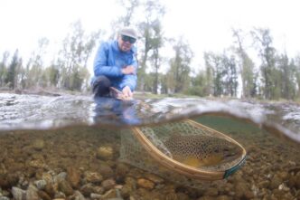
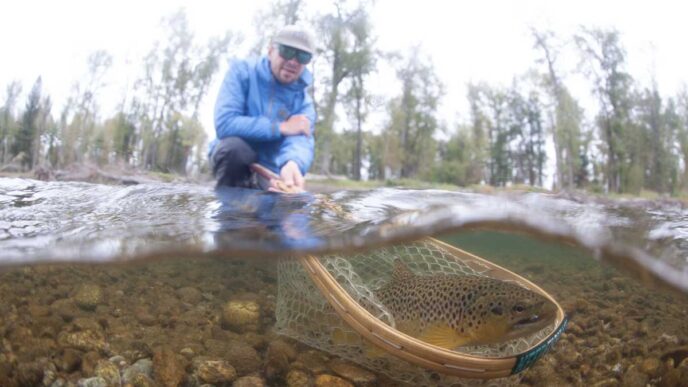
As for the fish? They clearly had survived the immediate aftermath of the fire. The creek itself looked mostly fine — willows and streamside brush were still present, and the water was flowing clear and cold as always. There were plenty of feisty mountain trout, spooky as always, to swipe at (or refuse) the late-season grasshopper pattern I floated past them if I didn’t scare them first. I had a pretty good day for the end of the season, maybe a dozen fish brought to hand in half a day of angling. Nothing big, but no big fish expected, either. That’s how these creeks generally play out.
In the summer of 2022, I hiked into another headwater drainage that had burned in 2014. The trees in much of this area were all completely killed, and the trail was challenging to navigate in spots due to downed trees. The underbrush had come back strong, but it was still hiking through low chaparral where there had been a forest before. The creek I fished was running clear and held trout, though I suspect they were smaller and fewer and spookier than when they lived in a creek that flowed through a dense forest. But they were survivors.
So maybe it’s all going to be OK. The Caldor, Dixie, Creek, and Castle Fires were all big. The USFS had its hands full cleaning things up enough to reopen trails and campgrounds safely after the fires ended. In some cases, it took one or two years, but they have been able to reopen most areas to visitors. Some regions looked like moonscapes, while others were a little less scorched, and some seem to have survived well. Fires in the summer of 2022 were much less destructive than in previous years. Every year, I hope for a winter with at least average snowfall. As a lifelong resident of California, however, I’m not holding my breath on that one.