

If I am not actually fishing, I am often thinking about fishing. Whether I am planning an upcoming trip, wondering what you could tie with the patch of fur that I found on a hike, or just sitting quietly, enjoying the memories of fish I’ve caught, I spend a lot of my time contemplating fish. You get a sense of what it is that actually draws you to fly fishing by looking at the common threads woven throughout these daydreams. Surprisingly, for me, the lure is not so much the fish themselves, but the water. To be sure, I can call up specific fish, the well-selected pattern or effective drift, but I mainly fantasize about the streams. Even though I have enjoyed some amazing days on alpine lakes set in dramatic rock basins, I am a moving-water kind of person. For me, streams are not just the stage settings on which the fish are the stars, they are the crux of my experience.
People who fish tend to experience their streams as a series of snapshots frozen in time. But streams and rivers are living things, capable of growing more or less healthy over time. It can be difficult to assess the status of the water if you visit it only a day or two each year. What has been a gradual decline can be experienced as a sudden shock. As we are being reminded this year, California waters are subject to a wide variety of stresses, and it is simply wishful thinking to expect that they be entirely pristine or that those that are will remain that way. All is not dark, however. Fortunately, it is possible to reverse declines in a dramatic fashion.
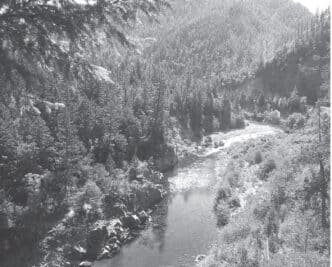
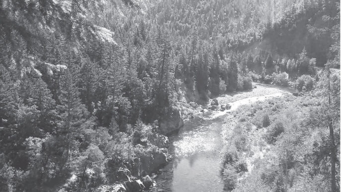
More than thirty years ago, I spent a day fishing McGee Creek, near Mammoth Lakes. I have vivid memories of that day, because the location of the creek is stunning. McGee Creek flows eastward from the Sierra crest before emptying into Lake Crowley. Along the way, it traverses the Long Valley caldera, a broad valley formed by an ancient cataclysmic volcanic explosion that sent dust and ash thousands of feet into the air. Debris from this event traveled as far away as what is now the state of Nebraska. Lake Crowley is set in the southern end of Long Valley and is a magnet for thousands of anglers, who ply its waters for large and healthy brown and rainbow trout. The lake is fed by several streams, including the upper Owens River and Convict and McGee Creeks. The Owens is the largest of these, coming together at Big Springs and traveling 17 miles through the valley to its meeting with the lake. The Convict Creek stretch in the valley is 7 miles long, and McGee Creek’s is 5 miles.
I first went to McGee on a sparkling clear fall day, mostly sunny, but with a dramatic buildup of clouds along the Sierra crest. I followed a set of directions that may or may not have gotten me to the stream without trespassing. (I am pretty sure the statute of limitations has run out, and I have since fessed up to the landowner.) There certainly were fish. Many, many brook trout came to me over a period of several hours. Each time that I paused and looked up, the views from the valley floor of the two mountain ranges on either side were amazing. The fishing was easy, and I had the place pretty much to myself.
Sounds ideal, huh? But I did not go back. Truth be told, the little creek was kind of sad. There were no trees or other vegetation. The stream was wide, shallow, and mud-filled. The water, even in what shade there was, was warm. Although lovely, the fish were uniformly small. The joy of that day was the place, not the fish.
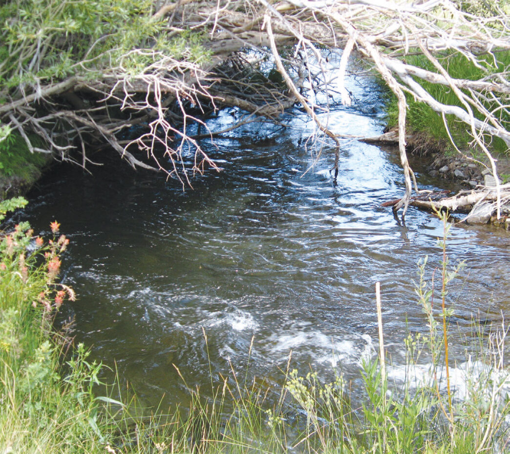
Some twenty years later, I wanted to show my wife the beauty of being in the middle of Long Valley, so, the fishing notwithstanding, I took her to McGee. We parked in what was, to me, a new designated parking area east of Highway 395. The first thing we saw was a sign that announced the area was a part of a program undertaken between the Los Angeles Department of Water and Power and the ranching company leasing the land from the department. We walked toward the sound of moving water, which we could not see, due to the dense stands of willows. When it came into view, I found that McGee Creek had become a stream with cold, clear water running between well-defined banks. There were riffles and pools and undercut. We took fewer fish than I did in the past, but they were larger — healthy rainbows and browns. On this day, the joy was more than being in the beauty of Long Valley. It lay in discovering this “new” creek. Again and again, I told my wife that I could not believe this was the same place and wondered at what had wrought the change in the stream.
The magic was the project explained by the sign at the parking area. Many times, a restoration project is undertaken and, after it moves forward, it is difficult to find anyone who is willing to be associated with it. Not so with Long Valley’s restoration. If you talk with the ranchers, the Lahontan Regional Water Quality Control Board, the California Department of Fish and Wildlife, California Trout, or the Los Angeles Department of Water and Power, they will all tell you about “their” project with an obvious sense of pride. Unbeknownst to me, when I first laid eyes on McGee Creek, there were a lot of concerns over conditions in Lake Crowley and its tributaries. Fish and Game, CalTrout, and many anglers were worried about the Crowley fishery and declining spawning conditions. The ranchers were concerned about the health of their pasturelands, the productivity of their herds, and the impact of human activities on their land and the streams that ran through it. The regional water board and the City of Las Angeles fretted over issues related to Crowley’s water quality.
Central to all of these problems was the conditions in the tributaries. What I had seen at McGee Creek was also typical at Convict and Mammoth Creeks and much of the upper Owens. Water quality in Crowley is directly tied to that of the streams. Long-term patterns of grazing and human impact resulting from recreation activities had severely stressed the riparian corridors. Soils were compacted and stream banks were trampled and denuded. Sections of streams had become shallow and wide, and silt deposits degraded spawning areas. The absence of vegetation and the shallow stream flows caused increasing water temperatures and decreasing levels of dissolved oxygen. Both the lake and the streams suffered as wetland habitats declined, losing their capacity for filtering impurities from the system.
The Lake Crowley Tributary Stream Enhancement Program was established to respond to these conditions. The core of the program lay in the establishment of a vegetation zone along the stream courses. The strategy employed was to minimize bank impairments through careful management of human and livestock activities.
The meadows of Long Valley were not being overgrazed, but the grazing patterns made it difficult to develop wetland and woody plant species that are useful in managing floodplain impacts. The first step was to develop a timetable managing stream flows and irrigation diversions. Initially, peak flows were pushed through the streams in order to scour stream sediments from spawning areas, recharge the wetlands and riparian water table, and provide moist bedding areas that would encourage the sprouting of willows, cottonwoods, and other woody plants. The peak flows were timed to occur immediately before the seed release by the existing cottonwoods. After runoff drops back to pre-peak levels, water is released under a controlled system of pasture irrigation.
At the same time, grazing prescriptions, the installation of fences, and the reconfiguration of pastureland were undertaken to manage the timing and duration of cattle grazing near stream banks. Fence installation began in 1992. All told, nearly thirty miles of fencing were constructed on Crowley’s four major tributaries. The newly defined pastures were designed to create large riparian zones while allowing cattle direct access to water in limited areas. The fencing funneled the animals back away from the streams so that they did not remain there for extended periods. Deferred and rotational grazing limited pasture use, making the land more amenable to recovery. A direct result of these practices was the re-emergence of wetland capacity to restrain seasonal flows and filter water impurities. This, in turn, led to improved water quality throughout the system.
In addition to focusing on grazing, the project sought to reduce and manage impacts resulting from human recreation activities. Vehicle access to stream banks was closed, as were recreational vehicle roads that paralleled the creeks. This resulted in a marked reduction in runoff sediments and enhanced the success of vegetation recruitment. Designated parking areas allowed access on foot. Access gates were installed that are spring-loaded to assure closing.
It did not take long for the ecological system to respond. A key indicator was the establishment of new willows and cottonwoods. The process moved more slowly along the Owens River, due to differences in the timing of flows and seed disbursement, but all four tributaries demonstrated improvement in plant recruitment, coverage, and age. Stream sedimentation was reduced as a result of source control and seasonal flushings. The quality of the fishery in Crowley began an upswing, and the improvement of the streams, especially the smaller ones, has been striking.
Positive responses were not limited to stream-quality measurements. Pastures have become more productive, bringing an increase in the weight and health of the cattle. Despite an initial period during which people responded to the new fencing by cutting it, human impacts on the stream have been confined and minimized, and trash and litter has declined. The pasturelands now sustain increased bird populations, particularly migratory songbirds and raptors, and are home to rafts of wildflowers.
Last June, I spent an afternoon visiting McGee. The parking area held a few cars, and most of their occupants were concentrated in the first few yards of stream near the lot. I walked past this zone and on through newly sprouted grasses and colorful flowers. The songs of migratory birds filled the warm early summer day. My routine for this creek involves an initial walk of half an hour or more. This gets me away from other people, lets me calm down a little and take note of the stream conditions, and provides an opportunity to appreciate where I am. On this day, I walked as far away from the stream as I could through what, in a few weeks, would be grass growing as high as my waist.
When I could no longer resist the allure of the water, I was at a place where the creek meandered, throwing bend curves connected by faster slots. Looking closely, I could see flashes of activity on the part of the fish. I tied on an emerger pattern and began to work the fast water as it entered the heads of the pools. Although I am grateful for the emergence of dense patches of willows, it is sometimes difficult to keep that in mind while attempting to cast. Most of my presentation was done via downstream drifts. As usual, I missed the first few strikes through a paradoxical combination of not paying attention while simultaneously being too eager.
Finally, I settled down at a spot above where a slot heading for a pool curved gently under a bank protected by grasses and the branches of low shrubs. The bouncing fly was interrupted by a strong take from what turned out to be a lovely 10-inch rainbow.
It is rare for me to be able to land and release a fish quietly enough to allow me to take more than one trout from a single hold, but on this day, I was able to take two similar fish from this spot. After releasing the last one, I looked up and saw a pair of hawks soaring above the meadow and felt pretty good about myself.
The remainder of the day was just as pleasant. The fish began to turn their attention to the surface, and a switch to a Cutter’s Perfect Ant pattern proved very productive. Again, most of the fishing was downstream drifting. When I do this, I end up using a leader in excess of 10 feet, believing that I need to create this level of disconnection between myself and the fly. Other areas were fishable using a cast across and upstream to gain a short drift without drag. The trout, while not altogether stupid, were enthusiastic.
Toward the end of the afternoon, as shadows stretched eastward from the Sierra peaks, I found myself above a sharp bend that had driven woody debris into the far bank. Willow branches hung over the resulting pool, which might as well have had a sign reading “Fish Here Now.” I floated a size 12 Stimulator as close to the driftwood as I dared and was rewarded with a strong strike. I managed to keep the fish out of the wood and branches and landed a 14-inch brown trout, brilliant gold with bright sharply defined spots.
It was not likely that anything would happen that would trump this fish, so it was time to quit and walk back to the car. As I loaded up, I glanced over at the project sign and said a thank you to the Lacey and Wood Ranch folks and the L.A. Department of Water and Power.
California’s trout habitats are subject to many stresses. They feel the effects of a continual expansion in human population, the state’s intricate system of water management, changing weather patterns, invasive species, and the impact of a variety of human activities and uses. There are times when the local trout stream comes out on the short end of the stick.
Fortunately, a decline in the health of a creek or river is not irreversible. Many organizations and individuals throughout California are involved in projects that keep track of the health of many watersheds and the quality of the waters therein. Every restoration project begins because someone has noticed something troubling. Do not assume that the relevant management agency is aware of a stream’s condition. Let somebody know. It is helpful if you include photos or other documentation of what you have seen or experienced. Restoration involves a lot of work and can often be helped along through the volunteer efforts of fly-fishing organizations and committed individuals. This work can come in the form of cleanup days, vegetation planting, surveying, or other activities. There is much satisfaction in returning to a riparian area and seeing the trees you planted years ago are now providing stability to the banks and shade to fish. The streams of the eastern Sierra have given me years of incredible enjoyment, and I am grateful for the efforts to enrich the environment for the trout, as well as the chance to lend a hand. It is truly the least I can do.
If You Go…
Lake Crowley and its tributaries in Long Valley are located near the town of Mammoth Lakes on Highway 395 in the eastern Sierra. Mammoth is about halfway between Reno and Los Angeles and in the summer is reachable from Northern California via Tioga Pass. The town is west of Highway 395, on Highway
203. Access to the upper Owens and Convict Creek is off Benton Crossing Road, which runs east from 395 about three miles south of the 203/395 junction. The McGee Creek parking area is another four miles south of the Benton Crossing Road. Mammoth Lakes has full services for visitors, including lodging, camping, food, fly-fishing outfitters, and supplies. Contact the Mammoth Visitor’s Bureau for more information, (760) 934-2712. Fishing information and equipment can be found at the Troutfitter, (760) 924-3676; Kitteridge Sports, (760) 934-7566; or Rick’s, (760) 934-3416. Check out their Web sites for updated information. For real-time information on stream flows in Long Valley, go to the aqueduct section of the Los Angeles Department of Water and Power’s Website, Aquaduct/realtime/lvrealtime.htm.
Convict and McGee Creeks are subject to special regulations from Opening Day through Memorial Day and then from October 1 through the end of the season. The upper Owens is open to fishing all year and is subject to a complex set of regulations at various times and locations. These regulations apply to fish size, bag limits, and barbless-hook restrictions. Check with the Department of Fish and Wildlife or local outfitters. The regulations are also posted at all of the streams.
Peter Pumphrey


")