

Winter nights bring out the dreamer in me. Sitting next to a fire with a couple of maps and a glass of wine, my mind wanders into the backcountry of the eastern Sierra. Sometimes I try to picture locations to which I have never been, trying to put real dimensions to contour lines, imagining the structure of granite bowls, and picturing the gradient of the streams represented by little blue lines.
Other times, I let my thoughts return to sights I have seen, but am not sure I remember accurately, because they were so scenic or the days so nearly perfect. One such place is Lamarck Col, with its collection of sparkling, high-altitude lakes set in an expanse of granite spires and massive peaks. (A “col,” by the way, is a depression in a range of mountains, often creating a pass.) The area is named for Jean Baptiste Pierre Antoine de Monet de Lamarck, a French evolutionist whose writings preceded those of Darwin and the others memorialized in the Sierra’s nearby Evolution group of peaks. I don’t know the significance of the “Monet” in the name, but the Impressionist painter would have found inspiration in the landscape of the col.
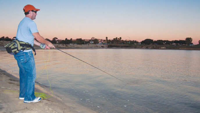
Lamarck Col lends itself to both day hikes and overnight trips, and from there, an ambitious cross-country route provides the most direct access from the east side to the wonders of Evolution Valley and the John Muir Trail. To reach the trailhead from Bishop, take Highway 168 ( West Line Street) 18 miles west. Follow the road past the turnoff to South Lake and through the small community of Aspendell. After 18 miles and just before the Lake Sabrina Campground, a dirt road takes off to the right. This road is clearly marked for North Lake, and it climbs about a mile to North Lake (at 9,360 feet). The road is narrow, sometimes a single lane with turnouts, and it leads to a parking area near the Bishop Pack Station. The trailhead is reached by walking up the road to the U.S. Forest Service campground. Day hiking is unrestricted, but overnight trips are subject to a trail quota, with a Wilderness Permit required, and there are food storage and campfire restrictions.
The Lamarck Col Trail takes off to the south from a clearly marked point in the campground. It crosses a bridge over Bishop Creek, passing through a wet area that contains monkshood, wild onions, shooting stars, and other seasonal wildflowers. Entering the cover of aspens and pines, the trail begins to climb a series of switchbacks to a point just short of 10,000 feet, where it enters an open, level area. At this point, the first views of the Lamarck Basin appear, defined by Mount Lamarck, Muriel Peak, and the ridge that divides the drainages of Lake Sabrina and North Lake. At the end of the summer season, the North Lake–Lamarck area is aflame with red, yellow, and orange aspens and willows that attract crowds of photographers and fall-color enthusiasts.
Grass Lake
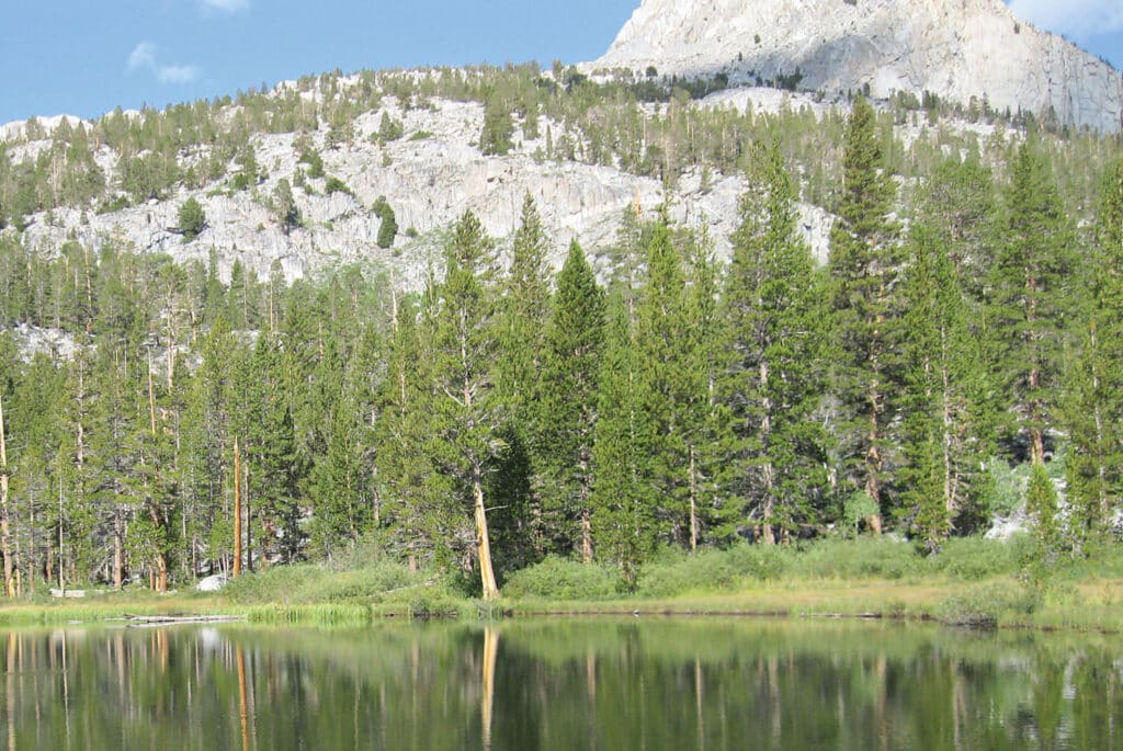
Just before the level ground gives way to another climb, a lateral trail leads to Grass Lake, which is about a mile and a half from the trailhead. The trail is marked by a sign that has been supplemented by someone wielding a fluorescent sharpie on a granite boulder. To reach Grass Lake, descend half a mile down a rock slope along a path that is sometimes difficult to locate. The small, aptly named lake is located in a marshy area filled with waist-high reeds. Two-thirds of the shoreline is taken up by this swampy ground, but there is a forested area at the northeast end of the lake and there are a few campsites above the swampy area.
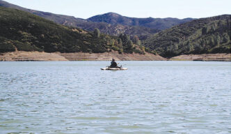
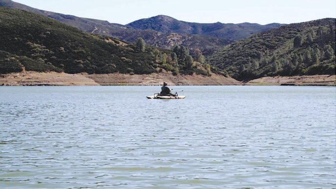
The last time my wife and I visited Grass Lake, we worked our way to the forested area, avoiding the obviously wet zones. I had wanted to try the inlet stream, but gray clouds coming in from the southeast convinced me to forgo the slog through the reeds and instead take advantage of the open shoreline. Although it was just after nine in the morning, the sun was only starting to touch the surface of the lake. Fish were visible near the shore, and rises dotted the surface within casting range.
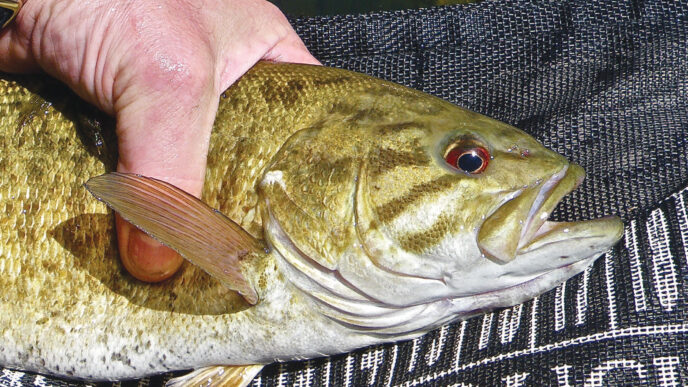
We rigged up and began casting dry flies, beginning with Cutter’s Perfect Ants tied on 6X tippets. Brook trout flashed to the flies as soon as they hit the surface, and I could watch them rise to the take. Naturally, I missed the first three or four of these connections due to the influence of
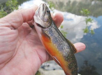
adrenaline, but I finally connected and landed a brightly colored fish with vivid spots and a bright red belly. The trout here are not large — a foot-long brookie would be a real prize — but they are strong and willing. The trees took several flies, but every pattern I tried (Cutter’s Perfect Ant, Orange Humpy, Royal Wulff, and Parachute Adams) brought fish. As good as the angling was, I was constantly diverted by the views of the Sierra Crest and the masses of Mount Lamarck and Muriel Peak. I spent time trying to trace the route up to the notch that forms the col itself. The bite slowed as the sun rose higher in the sky, but we continued to take fish until the lowering, windblown clouds offered a strong suggestion that it was time to get off of the mountain.
Other Waters
Past the Grass Lake junction, the main trail begins another climb through a series of steep and exposed switchbacks. Unlike the initial section of the trail, this area has little if any forested shade, and to avoid the heat of midday, you need to make an early start. The hiker traverses a landscape of granite layers and large boulders. Each north-facing switchback brings a dramatic view across Bishop Canyon toward the Piute Pass Trail and down into North Lake. It is spectacular in late September or early October.
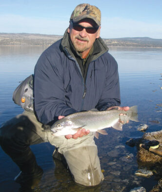
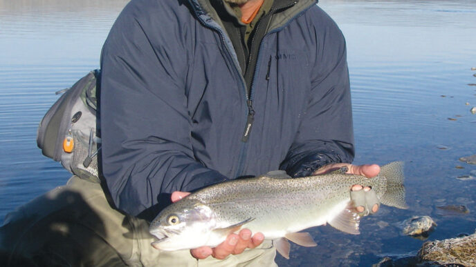
The trail leads to Lower Lamarck Lake (at 10,662 feet), which is three miles from the trailhead. The lake is a welcome sight after the unrelenting climb. The large peak across the lake is named Peak 12,153. Granite slopes drop into the depression that holds the lake. The shoreline is composed of rocky slopes and shelves, interspaced with clumps of willows. Though larger than Grass Lake, Lower Lamarck is still on the small side. There are several good campsites in the last forested areas of the basin. The lake bed deepens quickly near the shore, except at the inlet and outlet streams. The angler can work these shallow areas in the early morning and late afternoon, then move to the drop-off edges when the sun is higher in the sky. The lake holds rainbow and brook trout. The former are larger and the latter are more numerous. Like all of the brookies in the basin, those of Lower Lamarck are dazzling to look at, and their fight is disproportionate to their size.
Lower Lamarck is an ideal spot for a base camp to spend a couple of days exploring this compact area. A cross-country trek leads to the Wonder Lakes chain of 10 or so ponds and lakes, which lies beyond a ridge to the northeast. The lakes are designated as Wonder 1 through 6. The Wonders drain into Lower Lamarck, and their connecting stream, as well as the outlet from Lower Lamarck, should not be ignored. Wonder 1 (at 10,800 feet) is found half a mile above Lower Lamarck. The route is vaguely marked by a use trail, and the going is fairly easy to Lakes 1 and 2, becoming more difficult until you reach Wonder 6 after approximately two miles. The highest Lake is above 11,000 feet and is fed by a small, but impressive waterfall. The valley in which the lakes lie contains some small trees and a lot of willows. The shorelines of these lakes have the typical rock-and-willow cover. The Wonder Lakes contain populations of small brook trout, which, when combined with the setting, can make for a memorable day of high Sierra angling.
Upper Lamarck Lake is also accessible by following the defined Lamarck Col Trail a mile beyond the lower lake, with an elevation gain of about 400 feet. The maintained trail ends at a ford over the outlet from Upper Lamarck. Check out the stream, which, although small, is not without trout. Like so many high-altitude east-side creeks, this one is bordered by willows and has a pretty steep gradient. The willows provide cover and augment in-stream insect populations, making short-drift dry-fly fishing a satisfying way to spend a couple of hours before dinner or the hike back to the car.
Follow the trail upstream from the ford to reach Upper Lamarck Lake (at 11,100 feet). This lake is much larger than its lower brother, and the setting is very dramatic. The lake is framed by the Piute Crags and the bulk of Mount Lamarck (13,147 feet). There are no trees here, just streamside willows and short shrubs and grasses. Backpackers will find a few campsites, but they are exposed. The lake contains both rainbows and brook trout; these fish run slightly larger in size than those below. The shoreline is open for casting. My last trip here started with a bright sun in a deep blue sky, with rises all over the lake. Fish came readily to dry flies, especially at the outlet area. The day ended a few hours later with driving winds that presaged a hailstorm.
The maintained trail disappears at the ford of the Upper Lamarck Lake outlet. From the other side of the ford, the Lamarck Col route then takes off crosscountry. This route receives a lot of use, because it is the most direct route to Evo-lution Valley from the eastern Sierra, but it is still a cross-country affair, with no clear trail to follow. This is a long, steep, and strenuous walk and is for those experienced at high-altitude hiking and backpacking on loose rock, talus, and seasonal snowfields.
Beyond the ford, the route crosses a small meadow and heads up a steep slope. It continues up through a sandy stretch to a small lake that lies directly below the col. The lake is reportedly without fish. The route now crosses snowfields and angles to the left through the first notch to the right of a small, sharp spire. If you are interested in taking the Lamarck Col Trail to Evolution Valley or to hook up with the John Muir Trail, the many hiking guidebooks available for the area can provide useful advice. Also, make sure you get updated information about conditions from the Forest Service or local outfitter.
Watch the Weather
This is high and open country and is subject to the legendary whims of eastern Sierra weather. It is doubtful that there is a day without wind, which picks up as the day goes on. These winds have important consequences for both your fishing and your comfort. The winds bring insects to the trout via the phenomenon of updraft, by which insects from the lower elevations are carried on rising wind columns and deposited in high-altitude lakes in the afternoon. The winds also affect the casting at these high lakes, especially ones with the exposure of Upper Lamarck. Although I normally carry a lightweight rod (3-weight or 4-weight) into the backcountry, I bring a 5-weight or 6-weight if my only destination is one of these high, exposed bowls. You should know that the winds change direction during the day, so be prepared to move around the lake accordingly.
It is a cliché to say that weather in the high country is subject to rapid change, but if you ignore this warning, you have a chance for a truly unforgettable experience, and not in the good sense of “unforgettable.” Clouds can lie unseen on the western side of the crest and then boil over it, driven by high winds. This can produce a drop in temperature of 20 or more degrees in a matter of minutes. Add some wind chill and perhaps a little moisture, and the shorts and T-shirt that were perfect at the outset of your hike now compromise your safety. Check the forecast before you get in the car, even if you think you will being going for a only a short hike. Always carry extra layers for warmth, rain, and wind. If you carry one garment for the last two, make sure in advance that it will actually repel both rain and wind — many things that are said to be dual purpose are not. Carrying a bit of food, even on a short hike, is helpful, too.
At the other extreme is heat. Sunlight reflected from granite and water combined can generate a very high temperature and a lot of glare. I know from experience that this can be a recipe for heat prostration or sunstroke when you are several miles from the trailhead. Bring sunscreen, sunglasses, and a hat. Drink fluids before you set out, and keep hydrated throughout the day. If you wait until you are thirsty to drink, you have waited too long.
Finally, make sure you are equipped for when things to go wrong. Carry a firstaid kit, a signaling device, and an emergency kit. You don’t need the kitchen sink, but you should have what you need to stabilize a situation or keep yourself or someone else as comfortable as you can until help arrives. So far, I have been lucky enough that my emergency supplies have been used far more by people I have been met on the trail than by me.
Gearing Up
Fly tackle for the Lamarck Basin is the standard backcountry outfit. Because I will be walking to the fish, I want a rod that breaks down into four or five pieces so it is easily and safely carried in or on a pack. Because the fish are not huge, as I said, I usually carry a 3-weight or 4-weight rod, except when I know I will be in a place where I will probably have to contend with the wind. I fish a floating line, due to its versatility, and a short leader, because of the wind and the sometimes cramped quarters. I use 6X tippet, because the water in these places is very clear.
By now, everyone who reads California Fly Fisher probably knows that I fish dry flies even when it is plainly silly to do so. For that reason, my fly selection includes Cutter’s Perfect Ant, Royal Wulff, Elk Hair and E/C Caddises, Parachute Adams, and Parachute Blue-Winged Olive patterns in size 16 and 18 (some 14s for the ants), and Stimulators and a grasshopper patterns in size 10 and 12. My fly box also holds a few beadhead nymphs — Copper Johns, Princes, Hare’s Ears, and Pheasant Tails, size 14 to 18 — and a few Matukas and Woolly Buggers, size 8 to 12, because even I know when to yield to reality. With clippers, forceps, floatant, and my license, I am ready to go.
The approach to Lamarck Col opens the door to a variety of classic alpine fishing opportunities. For me, it is a great spontaneous destination for a half-day or day trip, because the trailhead is so close to where I live. If I were visiting and wanted a taste of the high Sierra, this trip definitely would merit consideration. It is also a good, if somewhat popular area for an overnight experience, and for the experienced and adventurous, it offers less-traveled access to the John Muir Trail and beyond. On top of that, no matter how much time you spend up near Lamarck Col, the memories will keep you warm on winter nights to come.
If You Go…
On the way to the trailhead, camping is available at Lake Sabrina, North Lake, sites along the South Lake Road, and at locations in Bishop Creek Canyon. For more information, contact the Inyo National Forest, (760) 873-2400 or www.fs.usda.gov/activity/inyo/recreation/camping-cabins. Lodging is available at Cardinal Village in Aspendell and at the Bishop Creek Lodge and Parchers Resort along the South Lake Road. Limited selections of supplies can be found in these locations. Motels are also found in Bishop. Fly-fishing tackle can be purchased at Brocks Fly Fishing Specialists, 100 North Main Street, Bishop, (760) 872-3581, www.brocksflyfish.com, and the Sierra Trout Magnet, 2272 North Sierra Highway, Bishop, (760) 873-0010, www.sierratroutmagnet.com. For information about lodging and services, contact the Bishop Chamber of Commerce and Visitor Center, 690 North Main Street, Bishop, (760) 873-8405, www.bishopvisitor.com.
For more information about day hikes, overnight trips, Wilderness Permits, trail quotas, and fire and food-storage rules, contact the Inyo National Forest, (760) 8732400, www.fs.usda.gov/inyo. Lamarck Col is within the John Muir Wilderness. If you cross the Sierra Crest via the col, you will enter Sequoia-Kings National Park.
Lamarck Col is depicted on the Mt. Goddard 15-minute and Mount Darwin 7-1/2-minute USGS topographical maps and the Bishop Pass Trail Map published by Tom Harrison Maps. Useful information can be found in Sierra South: Backcountry Trips in California’s Sierra Nevada (2006), by Kathy Morey, Mike White, Stacey Corless and Analise Elliot, published by Wilderness Press, in The High Sierra: Peaks, Passes, and Trails, third edition (2009), by R. J. Secor, published by Mountaineers Books, and by contacting the Inyo National Forest.
Peter Pumphrey


")