
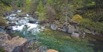

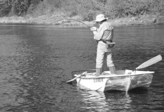
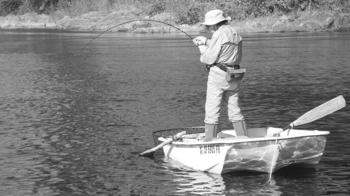
Canyon angler’s objective, in its purest form, is focused on seeking out fishable water that can be found only by identifying suitable canyons to visit, planning out a reasonable route there, and arriving safely at the chosen destination. That’s true whether the angler is an experienced canyon explorer or a neophyte. With experience, the sharp mental edges of that pure angling objective begin to blur and finally merge deeply with a vaguely defined combination of the many other elements of the whole canyon reality, including the joy of successfully locating and negotiating trails and immersing oneself in the beauty, history, and ambiance of the watershed. That’s not to say that the angling morphs into something that is unimportant — au contraire. It assumes its primal position in the hierarchy, once the selected watercourse is reached.
Veteran canyon anglers and hikers most likely need little or no assistance in going about the task of searching out information on trail and trailhead locations, but I will assume that the reader has little or no knowledge of how to find that type of information quickly and efficiently. The following discussion begins by identifying resources that contain general geographical information for large areas, then moves to other available resources that can help narrow down the search area sufficiently to pinpoint, to the extent possible, specific trails and trailheads so that relatively accurate, safety-oriented route planning can be accomplished.
Beyond employing the resources that are mentioned here, a canyon angler needs an inquisitive nature, a willingness to take a few informed risks, and an irrepressible drive to follow hunches, to learn about what may lie beneath the mountain ridges seen from the road, and to discover a hard-won “secret water” or two along the way. But for now, let’s stick with the nitty-gritty work and the how-to of finding suitable off-the-beaten-path angling venues.
Digital Resources: Blogs
Navigating the Internet in search of information on any specific subject can be as dangerous and tricky as negotiating a steep, narrow old miners’ mule-train track. While a skillful Web searcher can unearth a deluge of information, the tricky part is to winnow the sometimes tangled mass to eliminate the chaff and get to what’s actually important while avoiding websites that are phony fronts for undesirable interests. And so it is with using the Internet to track down accurate trail information. The principal online resources that I’ve found useful for finding and navigating trails to canyon fisheries have been blogs.
When you enter search parameters in your browser asking for trail and map information, a diverse selection of Web sites will appear in the list of results. Before opening any specific link, I try to read at least 25 of the listed site names and descriptions. Doing so will allow you to make a first cut by disregarding those that appear to be purely commercial solicitations and other distracting material and focusing on those that might prove to be productive.
Most useful are the blog sites that usually appear somewhere down in the list. In some cases, the bloggers will have actually hiked the canyons and found the streams, and they can provide first-hand information on trailhead location, the nature of the trail, what to watch for on the trail (especially trail forks and areas that are obscure), and warnings regarding dangers not apparent from maps. One of the best blogs I’ve ever had the fortune and honor to read was written by the legendary environmentalist, hiker, and explorer of the North and Middle Forks of the American River watersheds, Russell Towle. See, for example, http://northforkbookofdays.blogspot.com/2012_07_26_archive.htm. Russell was, unfortunately, killed in an automobile accident. An Internet search under his name will result in a huge list of references to his work, which is both entertaining and informative.
The problem with online searches is that what the search algorithms prioritize often doesn’t correspond to your own interests. For example, if you enter “Middle Fork American River trail map,” a plethora of information appears in the list of results. Most of it is related to whitewater rafting, however, and not helpful. But if you click on the U.S. Forest Service link, http://www.fs.usda.gov/activity/tahoe/recreation, a “Hiking” listing in the menu leads to a lot of trail information. Sadly, the “fishing” link on that same page is a useless single-paragraph blurb, and you need to dig deeper.
While the list of hiking trails on that Web page is useful for locating trails that lead to fishable water, sadly (again), in spite of the specificity of the inquiry, the trails that are mentioned do not relate to the Middle Fork of the American River, but to the river’s North Fork. That’s not to say that there’s anything inferior about the North Fork, because it’s just as good as an angling destination, but the point is that you are led to a different watershed.
At least the information you might need for that destination is there, however. Compare the specific information provided by this site with that found on the numerous sites that are whitewater-related, and you’ll find that the latter provide only general information and precious little specific material.
Books and Magazines
As one might imagine, there are a lot of books containing trail information. A visit to a good bookstore (rapidly becoming an extinct species, unfortunately) will provide a reasonable assortment of relevant books in the “Sports” stacks, and the ability to do a hands-on review of them all for relevance and specificity is one of the benefits of visiting a brick-and-mortar book vendor. Look for guidebooks, trail guides, and hiking and backpacking books, of course, but don’t neglect other possible resources, such as mountain biking books, sport-specific magazines, and locally published booklets, pamphlets, and local history books.
While stores offering only new books are helpful in a general way, I have managed to find many excellent books at local used book stores at a fraction of the new price, including some that contain local trail information. Combing through a used book store’s bins can unearth some real gems that cannot be found elsewhere.
Sometimes local libraries will have a good assortment of trail books, including some with relevant local information. If a particular library is affiliated with others in the region, they may have online information as to what is available at other branches. Modern library systems have their book inventories digitized, thus allowing users to gain access to the inventories of affiliates within the system. I have found this resource to be extremely helpful in reviewing materials in order to decide which, if any, would be valuable enough to purchase.
Knowledgeable librarians also can be quite helpful in suggesting alternative search avenues. For example, a librarian might recommend researching old mining claim maps — an interesting (and sometimes entertaining) source of historical miners’ trail information that can lead to an exploration trip to find the old trails. Miners historically located their claims on or near water, so such historical information is relevant both for angling possibilities and as interesting background.
Guidebooks or Trail Guides. Typically, trail guides relate to specific areas: a state or parts of a state (for example, Sierra North, 9th edition, by Kathy Morey, Mike White, Stacy Corliss, and Thomas Winnett [Wilderness Press, 2005]) or a region (for example, Tahoe Sierra, 4th edition, by Jeffrey P. Schaffer [ Wilderness Press, 1998]). Books of this type contain a broad array of specific trail information, including location, directions to the trailhead, trail length, degree of difficulty, elevation gain or loss, trail profile, and maps. They also sometimes contain information on available recreational opportunities associated with particular trails, including fishing.
Used book stores are a rich source for trail guide books. Don’t be frightened off by the fact that a particular book is an older edition — essential information doesn’t always change.
Hiking and Backpacking Books. This genre of books on backcountry adventures normally contains a lot of information on gear, food, preparation, and related topics. As such, they are broader in scope than guidebooks, but they sometimes also contain specific trail information. Again, used book stores often have a large selection of these works.
Mountain-Biking Books. Mountain biking is a popular sport that almost always takes place in canyon settings. These books contain a plethora of very specific trail information, which is what mountain bikers need. Consequently, they can be an excellent source of information for anglers desiring to gain access to canyon streams, assuming the book’s scope includes the angler’s intended destination.
A word of caution is appropriate here, though. Mixed-use trails can pose problems for hikers, especially when the trail is steep and narrow. It pays to remain vigilant by listening for the sound of approaching bicycles where vision ahead or behind is obscured by cliffs, rocks, brush, trees, or a combination of obstacles. Hiker-biker collisions can result in very serious injuries. The best advice I can offer is to give way to an approaching cyclist, where possible, given the nature of the terrain. If there are blind turns ahead or behind, create a lot of noise to make your presence known.
Magazines. There are sport-specific magazines, such as those relating to hiking, backpacking, horseback riding, and mountain biking. These can provide useful information on trails that are of interest to canyon anglers.
Local Publications. Where there are deep canyons, there are usually trails that provide access to the streams that run through them. Where there are trails, there will often be locals who frequent them. If you are lucky, you may find booklets or even trail-related books written by locals in your intended area. While they are sometimes roughly written, they are generally packed with accurate, specific information about local trails — information that cannot be found elsewhere. For the watersheds that I haunt most, there is a rich supply of this type of publication, most of which was authored by my friends Tom Peterson and Ron Gould. Tom Peterson has written a series of small books on trails in the watershed of the Middle Fork of the American River: Georgetown Trails: The Search for Greener Pastures, 5th edition (Get Off Your Gass Publishing, 2011) and Trespasser’s Paradise Near Georgetown: Trails for Outlaws and Wild People (Get Off Your Gass Publishing, 2008). Ron Gould’s excellent book relates to the North Fork of the American River: North Fork Trails, 2nd edition (self-published, 2010). Other valuable local books, unfortunately no longer available, were written by Gene Markley, a famous local environmentalist, teacher of backcountry skills, and canyon sojourner: Bogus Thunder Mountains (Pete Ramble Publications, 1976), Sojourning in Rough Country (Pete Ramble Publications, 1977), The Sugar Pine Journals (Pete Ramble Publications, 1979), and Hills of the Coyote (Pete Ramble Publications, 1980). These books consist mostly of bits of history and stories based on that information, but are valuable from an angler’s standpoint because they almost always are directly related in some way to local waters.
In my experience, this type of literature is without doubt the richest source of reliable, accurate trail information. While it may or may not be available for other areas, it is definitely worth digging around for such materials in local libraries, used book stores, and sporting-goods stores for “local color” before venturing into unfamiliar territory.
If you have the good fortune of locating a nearby fly shop, you also may be able to lock onto some good information from the “shop dogs” or the owner. Still, be careful about accepting the word of locals regarding location of fishing venues. I have found that in many cases, such oral information will be incomplete or inaccurate, so it pays to check it with other sources before venturing out.
Maps
Your research will be incomplete unless you consult relevant maps for your intended destination. While there are myriad types of maps available, I have found the following to be the best available visual aids. In order of usefulness, beginning with the most useful, they are U.S. Forest Service maps, National Geographic forest maps, United States Geological Survey topographical maps, mapping software, and commercial trail map sites.
U.S. Forest Service Maps. These maps are available at ranger stations located in national forests throughout the country. Often, the station store will carry maps of adjacent national forests, since particular trails and rivers do not always respect designated boundaries. Each national forest prepares its own map, which can lead to qualitative differences in presentation and accuracy. However, on the whole, these maps are excellently drawn, filled with features, and regularly updated. They are generally drawn to a 1:126,720 scale, which in terms of size is relatively gross; however, this is understandable, given the breadth of territory that these maps are designed to cover.
Although they do not contain topographical information, I always begin my map research with the relevant national forest map in order to locate road networks, landmarks, streams, and associated trails. For my home watersheds, I have well-worn, heavily marked-up versions of U.S. Forest Service maps for both the Tahoe and Eldorado National Forests.
My advice is never to pass up a Forest Service ranger station without paying a visit to talk to the staff and look through their inventory of materials. The same applies to ranger stations in national parks, as well, which always have staff members eager to provide helpful information. In fact, the staffs at national park ranger stations have a somewhat different, more tourist-oriented mission than those at national forest stations, which serve multiple interests, such as hikers, backpackers, anglers of all types, miners, off-road-vehicle enthusiasts, logging interests, mountain bikers, and history wonks. I have found that national park maps tend to be more detailed and more specific than national forest maps, perhaps because of the sharply different focus of the two agencies.
National Geographic Forest Maps. Maps in this excellent series generally follow national forest boundaries. They are very detailed, with prolific trail information. However, I have found many inaccuracies of description or location for specific trails, so caution needs to be exercised. For that reason, I always use USGS topographical maps in conjunction with the National Geographic maps as a method of cross-checking information. These maps are drawn to a 1:63,360 scale, which is twice as fine as the USFS national forest maps. The result is that more than one map may be required for a particular national forest area. Additionally, these maps contain detailed topographical information, with a contour interval of 50 feet. They are excellent tools for locating trails and streams and for route planning. National Geographic forest maps are available from the National Geographic Store, http://shop.nationalgeographic.com, and from many outdoor stores.
United States Geological Survey (USGS) Topographical Maps. These readily available, inexpensive, highly accurate maps are essential to anyone frequenting the backcountry, whether sticking to established trails or venturing off cross-country. Topographical contours describe the landscape in two dimensions, instead of one, as in the case of the national forest maps, thus allowing the backcountry traveler to keep accurate track of his or her position by reference to natural landscape features. Topo maps are available for virtually any area in the United States and Canada, as well as for other parts of the world.
For the United States, each state is divided into quadrangles with an assigned name. Quadrangles are based on lines of latitude and longitude. There are two “series” of USGS topo maps: the 7.5-minute series, which covers an area equal to one-eighth of a degree of latitude and longitude, and the 15-minute series, which covers an area equal to one-quarter of a degree of latitude and longitude. While the 7.5-minute series maps cover a smaller area, I prefer them, because they are more detailed. The map scale for a 7.5-minute topo map is 1:24,000, which translates to one inch equaling 2,000 feet on the ground — approximately three-eighths of a mile. The 15-minute topo map scale is 1:62,500, which translates to one inch equaling one mile on the ground.
There is a free map index that shows all of the quadrangles for each state and their geographical locations. This index and any desired maps can be obtained by calling the U.S. Earth Science Information Center (the USGS’s marketing arm) at (888) 275-8747 or by visiting their Web site at http://www.usgs.gov/pubprod. USGS topo maps are also available through outdoor retailers such as REI, retail mining equipment stores, and sporting-goods stores. For a full discussion of USGS topo maps and how to use them, see The Essential Wilderness Navigator: How to Find Your Way in the Great Outdoors, 2nd edition, by David Seidman and Paul Cleveland (Rugged Mountain Press, 2000).
Mapping Software. There are a number of providers of electronic maps (see The Essential Wilderness Navigator for a list), but I use a program called Topo! (California), which is marketed by National Geographic, as well as Garmin’s Topo U.S. 24K West program. Both of these programs can be used to create 1:24,000 scale topographical maps and routes for any geographical area within the program’s area parameters. These software programs can also be used to download mapping information to hand-held GPS receivers and to upload information on routes, tracks, and waypoints from hand-held GPS units. I am certainly not an expert at using these programs, but happily, I don’t need to be one. My main purposes in using digital resources is to locate trails and trailheads for trip planning, to create digital maps, and to then establish a permanent record of the trips I’ve taken by uploading data from my GPS and placing that data on the digital maps.
These software programs are updated periodically. In the past, Garmin has not charged me for their updates, but I believe National Geographic does charge a fee for that service.
Commercial Trail Map Sites. Commercial sites such as American Trails require membership for access to specific trail information. The free portion of the information found at the link is normally very general, with a map that is of such small scale as to be of little use, except to locate the general area where the trail can be found using other resources. I have never subscribed to one of these services, because there is plenty of free (and usually much better) trail information available, both online and in older media.
Recreation Agency Offices
Federal government agencies like the U.S. Forest Service not only publish maps, but are a useful source of all kinds of information needed by the explorer of backcountry canyons. So are state agencies such as the California and Nevada Departments of Fish and Wildlife and the state parks departments of California and Nevada, as well as county and local parks departments.
U. S. Forest Service Ranger Stations. As mentioned above, I never pass up a chance to visit a ranger station when I’m in an area where one exists. These stations can be a very rich source of current information about local hiking and fishing. I am fortunate to live only three miles from the Foresthill Ranger Station in the Tahoe National Forest, and I make a point of visiting the station regularly to chat with the staff and, on occasion, to report law-enforcement issues that I’ve encountered in the woods. Like many other ranger stations, the Foresthill office has a large sheaf of photocopied trail maps that are given to visitors free of charge. These highly accurate, information-packed maps supplement the national forest maps that they sell (for approximately $9.00) with information on trail locations, lengths, profiles, and degrees of difficulty. The friendly staff also is quite helpful in providing access to information, such as temporary closures, potential dangers, and blockages that affect access. They also provide information on car camping and wilderness areas located within the national forest boundaries. For example, the Tahoe and Eldorado National Forests feature two large wilderness areas, the Granite Chief Wilderness and the Desolation Wilderness, each of which have numerous recreation and angling opportunities. For those interested in historical and cultural information about canyons and other features, most ranger stations also have a designated professional responsible for maintaining that type of information, including the potential for finding petroglyphs engraved on rock structures by Native Americans, along with other artifacts — a truly fascinating subject that can make a canyon angling trip even more memorable.
California Department of Fish and Wildlife and Nevada Department of Wildlife Offices. Another rich source of information on canyon angling can be found in the offices of your state fish-and-game department, especially from their biological and enforcement staffs. Many of these staff members actually get out in the field for scientific and law-enforcement purposes, and they can be a fount of valuable information on canyon angling. I have found that game wardens, when treated with the respect that they richly deserve, are very helpful and willing to share their experiences in the field.
Another California DFW resource is the staff of the Heritage and Wild Trout Program. Although these staff members are out in the field so much that they can be difficult to reach, they are extremely knowledgeable about trout populations in wilderness settings, because their work includes doing fish population and related studies in such venues for the purpose of their potential designation as Wild Trout waters. It therefore pays to engage the staff, if possible, in conversations regarding the particular venue that you are targeting. They may not have all of the information you are seeking, but they are quite good at pointing you in the right direction to find it. The California Department of Fish and Wildlife has an excellent Web site at http://www.dfg.ca.gov, and Nevada’s Department of Wildlife can be researched at http://www.ndow.org.
In addition to the fish-and-game department itself, there will sometimes be a state fish-and-game or wildlife commission whose functions are to address regulatory issues, enact regulations, and make recommendations to state and local governments. In some states, such as California, there are local subcommissions that gather information and make recommendations to the statewide commission. California’s statewide commission can be located at http://www.fgc.ca.gov. Counties have local subcommissions such Placer County’s. See http://www.placer.ca.gov/bos/ComComNu/ComComAtoF/FishGame.aspx.
State Parks Departments. Sometimes venues for canyon angling will be located in large state parks or in areas managed by the state’s parks department. A good example of this is the Auburn State Recreation Area, located in Placer County, California. The recreation area, a vast land mass owned by several federal agencies, is managed by the California State Department of Parks and Recreation under a management and funding agreement with those agencies. Because the recreation area covers a portion of both the North and Middle Forks of the American River watersheds, there is some canyon angling available to the area’s visitors. The parks department publishes an excellent trail map showing all of the area’s trails, most of which are designated for multiple uses — that is, by mountain bikers, equestrians, hikers, and anglers. Motorized vehicles are prohibited on these trails, but there is also a separately designated off-highway-vehicle park in the recreation area to accommodate them.
It is a good idea to check the particular locale you intend to visit to see whether there is a state park that includes available canyon angling venues or possibly a recreation area that is managed by the state’s parks department. State parks departments generally have Web sites that can be very helpful. California’s Department of Parks and Recreation has an excellent Web site at http://www.parks.ca.gov, and Nevada’s Department of Conservation and Natural Resources, which runs its state parks, can be researched at http://parks.nv.gov.
Local Recreation Districts and the Recreation Departments of Local Governments. Local recreation districts are sometimes formed by state legislatures for the purpose of owning and managing parklands that cross local government jurisdictional boundaries. These single-purpose districts may cover areas that include canyon angling venues and normally will have detailed maps of the parklands that they own and/or manage. A good example of an independent recreation district is the Auburn Recreation District, whose Web site can be found at http://www.auburnrec.com.
Additionally, county and city governments (specifically, their parks departments) often own and/or manage regional and local parks. They, too, will almost always have detailed maps available, as well as a Web site. For example, see http://www.placer.ca.gov/Departments/Facility/Parks.aspx.
It always pays to check these agencies for information when planning a trip that includes a destination located within their boundaries.
Nongovernmental Organizations
Finally, there are normally numerous nongovernmental organizations (NGOs) that have specific wildlands as their area of interest. These groups may cover a broad range of interests, including local trail maintenance groups, hiking clubs and endurance-running groups, mountain-biking and equestrian clubs, fly-fishing clubs, Sierra Club chapters, mining clubs, and local historical societies. It takes a bit of digging to find them, but local retailers (small sporting goods and outdoor equipment stores, for example) and libraries can often provide contact information. Also, since many of these groups are politically active on a local basis, their contact information may be available from local government agencies. If you are able to contact one local NGO, that group can also be a source of information on similar or related groups within the area.
Local Trail-Maintenance Groups. Government agencies are strapped for cash and rely heavily on private groups to assist them in maintaining trails. Federal, state, and local agencies welcome the help and expertise that this type of user group can provide. I belong to a number of them, including the North Fork American River Alliance (see http://www.nfara.org) and Protect American River Canyons (see http://www.parc-auburn.org).
Hiking Clubs and Endurance-Running Groups. Hiking clubs frequent local trails, including deep-canyon areas. There are a number of ways to locate these NGOs, but the effort will pay off. Endurance runners engage in competitive events and train on canyon trails. As such, they are a good source for deep-canyon trail information. See, for example, http://www.wser.org.
Mountain-Biking and Equestrian Clubs. Mountain bikers are very well organized, have excellent communication networks, and frequent many backcountry trails, some of which are deep-canyon trails that lead to fishable water. They are easier to find than other NGOs — all you need to do is visit one or more of the local bicycle shops. Equestrian groups, especially those that are endurance oriented, are also somewhat easier to locate than many other types of NGOs. Information on these groups can be found at local equestrian equipment stores, local feed stores, and sometimes at local government park district or department offices, since equestrians are vocal about trails and engage in political issues. A good example is the group organized to handle a 100-mile race known as the Tevis Cup. (See http://www.teviscup.org.) Endurance groups always ride on backcountry trails and are an excellent source of information for anglers desiring to find new deep-canyon streams.
Fly-Fishing Clubs. In searching for canyon angling venues, always look for a fly-fishing club in the vicinity of your intended adventure. If a fly club is within a reasonable distance from that venue, and if the club has a Web site, there will likely be directions on their site regarding their meeting time and place, and you may be able to make arrangements to attend one of the club’s meetings or otherwise correspond with club representatives. Usually, these clubs are very willing to share information and will try to accommodate interested anglers from out of the area. Sometimes the club’s newsletter is posted on its Web site. See, for example, http://www.gbflycasters.org.
Sierra Club Chapters. The Sierra Club has a large number of local affiliates known as “chapters.” These organizations are easily located and can be a marvelous source of information regarding local canyon streams and the trails that access them. Be sure to check the area where you intend to look for deep-canyon fishing venues to see if there is a nearby Sierra Club chapter. Use the following link for assistance in locating a Sierra Club chapter: http://www.sierraclub.org/chapters.
Mining Clubs. Canyon anglers sometimes have issues with certain canyon mining practices and with the sometimes belligerent attitude of miners working their claims. Nothing could be farther from the truth, however, than the notion that all miners found in canyons are evil folks. In fact, most are friendly and law abiding, and members of mining clubs are very familiar with canyon trails and streams, because that is how they ply their hobby and trade. These local clubs can be a bit difficult to locate, but a visit to a mining supplies store in the vicinity will normally be productive for club contact information, trail information, and maps. See, for example, http://www.pioneermining.com.
Local Historical Societies. Historical societies normally sponsor museums and other local events and have memberships that are highly interested in local historical venues. In some areas, these will include canyon areas and streams. By contacting local historical societies, visiting the museums that they help maintain, and finding out about maps and archives that contain information that cannot be found anywhere else, I have been able to unearth a lot of valuable information on old, unmapped trails that have led me to fishable waters. See, for example, http://www.placercountyhistoricalsociety.org.


")