
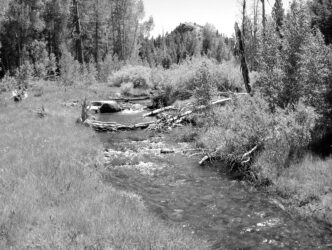

Maps fascinate me. They turn a complex world into two easily comprehensible dimensions, and a good map can help me find places where I might want to escape the workaday world and fling a fly. For me, more often than not, those places are small mountain streams.
“Small streams” — these words invoke fond memories dating back some 60 years. Growing up on the west slope of the Cascades in Oregon, my earliest angling forays were along the streams of the Willamette River drainage. There, I developed an appreciation for the beauty and intimacy of small streams, qualities that larger waters often can’t match, and that is what motivates me to seek out small streams to fish.
Resources for Finding Streams
When I look for a small stream, the ideal kind of stream that I seek is one that will have countless trout and no people. You can be sure that if I ever find that stream, I’ll keep its location a secret. What follows, however, is no secret. Although not an exhaustive survey, I present the primary techniques, products, and tools that can help you find your own ideal small stream. Several questions come to mind when I’m searching for small streams. What’s the location? What’s the topography of the area? Does the stream exhibit the types of features that support trout populations? What sort of access is available? Is the stream on public or private land? Are there fish in the stream? Unfortunately, this last question — the most important of all — can be answered only by on-site observation. Fortunately, the other questions can generally be answered with a good map without ever leaving the comfort of home.
Maps come in all shapes, sizes, scales, and amounts of detail. Some are truly things of beauty, while others are nearly useless, best kept folded and stuffed in the glove box of a vehicle for use only in a dire emergency, as the last possible resource when you are totally and completely lost.
Prior to the mid-1990s, when digital map software started to become available, the best maps to have for scouting out small streams were the U.S. Geological Survey (USGS) 1:24,000-scale topographical (topo) quadrangle (quad) maps, where one inch on the map equals 2,000 feet on the ground. These printed maps cover an area of 7.5 minutes latitude by 7.5 minutes longitude and display elevation contour lines, as well as natural and manmade features. Without access to the Internet or one of the various digital topo maps discussed below, you can find a complete list of these maps for California by requesting the California Index to Topographic and Other Map Coverage, product number 47436, which is free and can be ordered directly from the USGS Western Regional Office, 345 Middlefield Road MS 977, Menlo Park, California 94025. Once you’ve used it to identify the maps you need, you can order them directly from the regional office, or you can try to buy them at an outdoor-sports store.
In 1977, the USGS, in cooperation with the U.S. Fish and Wildlife Service, began a project at Fort Collins, Colorado, to digitize the topo quad maps. By the ear-ly 1990s, this digital database became available to software developers for use in commercial products. Today, there are a number of these products on the market, including on several Web sites, that allow for downloading and printing maps on a home computer. In addition, satellite and aerial photography overlays are available, along with 3-D renderings. Some of these map products are valuable resources in the hunt for small streams.
Atlases
Two atlases — collections of maps bound together in book form — are useful in scouting out likely small streams in California. The first is the California Road and Recreation Atlas published by Benchmark ($24.95). In addition to California highway and metropolitan-area maps, this atlas also contains 22 recreation-area maps and 76 landscape maps. The recreation-area maps are printed at a scale of 1:863,000, where an inch on the map equals 13.6 miles on the ground, and display public land ownership as color tints. The landscape maps are printed at a scale of 1:300,000, where an inch on the map equals 4.7 miles on the ground.
The second is the DeLorme California Atlas and Gazetteer ($24.95), which contains 138 quadrangle maps with a scale of 1:200,000, where an inch on the map represents 3.2 miles on the ground.
Prior to 2008, DeLorme published two versions of the California Atlas and Gazetteer, one covering Northern California and one covering Southern and Central California. The Northern California atlas contained 104 quadrangle maps with a scale of 1:150,000, where an inch on the map represents approximately 2.5 miles on the ground, while the Southern and Central California atlas contained 127 quadrangle maps at the same scale. The two volume set is still available from sources that have retained stocks of the old version; it is a bit more detailed than the newer single volume.
While an atlas is useful for providing a large-area overview and for locating general areas and/or features, specialized maps, including small-area topographical maps from government and commercial sources, both hard-copy versions and digital maps, are better suited to searching out small streams and answering the questions of topography, access, ownership, and features that support trout populations.
Specialized Maps
A number of useful paper maps are available that provide the type of detail needed to make the small-stream search more productive, and many of these are also available online in digital form. Maps published by the U.S. Forest Service, the Bureau of Land Management (BLM), the
U.S. Geological Survey, and numerous nongovernmental organizations are primary resources for searching out small streams that promise to hold fish, as are on-line resources available from Google Maps, Google Earth, and purveyors of commercial map software.
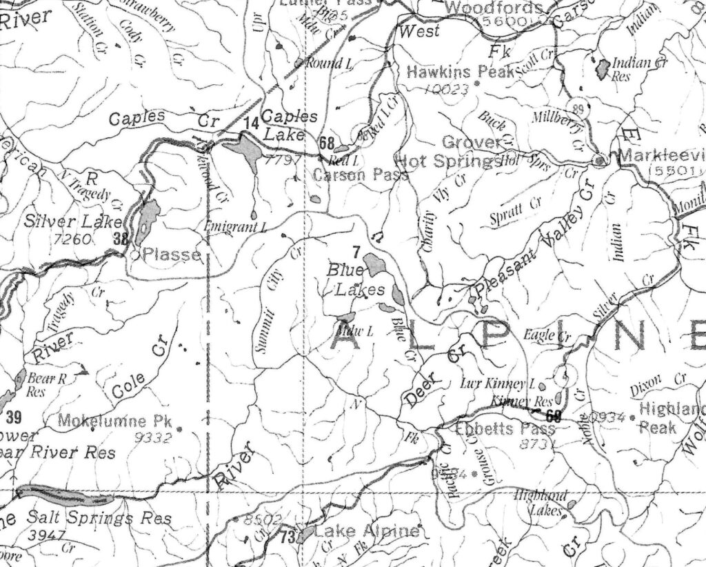
Two years ago, I discovered a map scaled at 1:500,000, where an inch on the map represents 8 miles on the ground, showing nearly all the 64,000 miles of streams and approximately 600 lakes, ponds, and reservoirs in Northern California. The map, called Professor Higbee’s Stream Map of Northern California, covers an area from the Oregon border to an eastwest boundary line that extends from 16 miles south of San Jose to just south of Bishop and shows some 3,500 waterways. The original Professor Higbee’s Stream Map was published in the 1960s for Pennsylvania, and editions are now available for 22 states and the District of Columbia, with new maps added each year. Fortunately for those of us in the West, maps of Oregon and Washington, as well as of Northern California, are currently available, and Southern California and Nevada maps are currently in production and are expected to be on the market in the near future. You can order copies of the relevant Professor Higbee’s Stream Map in a variety of hard-copy formats — folded paper or laminated and rolled ($19.95 and $39.95 for Northern California), or as a stunning, though pricey ($376.00) 6.8-by-7.9-foot mural — from http://www.streammaps.com/index.php.
The California State Automobile Association publishes a number of useful maps and guidebooks. These include the Guide Map for the Eastern Sierra and recreation maps for the Sierra Nevada-Lake Tahoe Area and the Sierra Nevada-Yosemite Area. They are available at local AAA offices and can be ordered on the web at trip. Access to maps is one of the reasons why anglers join auto clubs.
The U.S. Forest Service publishes 14 National Forest maps for California. These maps are at a scale of 1:126,750, where an inch on the map equals 2.0 miles on the ground. They are available as both paper map products at $9 each and as digital maps that can be accessed online at http://www.fs.fed.us/r5/forestvisitormaps. While the maps do not show detailed elevation data, they do depict land ownership and can be valuable for determining which areas are public and which are private.
There’s a good reason to pay attention to what’s public land and what’s private when searching for small streams to fish. The California Penal Code, section 602 PC (p) states that you are trespassing if you enter “upon any lands declared closed to entry as provided in Section 4256 of the Public Resources Code, if the closed areas shall have been posted with notices declaring the closure, at intervals not greater than one mile along the exterior boundaries or along roads and trails passing through the lands.” In addition, the California and U.S. government maps available on the Internet are not legal records of original survey measurements. They are representations or reproductions of information taken from original documents. As such, the maps do not carry legal authority to determine a boundary. You have the ultimate responsibility for knowing where public/private boundaries are and whose land you’re on.
The Bureau of Land Management produces a series of surface management maps that are more useful than the U.S. Forest Service maps for determining if a stream is on public or private land. There are 104 surface management maps covering California. These 1:100,000 scale maps, where an inch on the map represents 1.6 miles, show color-coded public and private land ownership, roads, water features, points of interest, and township and range lines. Some maps contain topographic lines, while others are planimetric, showing only the horizontal positions of features without regard to elevation. The maps sell for $4.00 each and can be purchased on the Internet or from any BLM district office or the state office in Sacramento. A map index is available from the district and state offices or online at iac/maps_pubroom.html.
The U.S. government also has two Web sites that provide access to topographical maps that can be downloaded and displayed on a personal computer. The USGS Web site at gs.gov provides access to free, downloadable topo 1:24,000-scale quad maps for any location in the United States. The BLM and U.S. Forest Service maps available at http://www.geocommunicator.gov provide the ability to search, access, display, and download mapping data, including BLM land ownership and township, range, and section data.
Clicking on the Map Locator & Downloader link on the USGS site displays a searchable U.S. map that can display maps in various formats, including topographical, satellite, and hybrid views. To navigate on the map, use both the mouse and pointer or enter a search name. Selecting Mark Points and placing a marker on the map and clicking on the marker allows for the downloading of 7.5-minute, 15-minute, or 30-minute quadrangle maps in Adobe PDF format that can then be stored and printed from your personal computer.
On the GeoCommunicator site, select Interactive Maps, then the Site Mapper to display a map of the United States. The four map views available are an aerial view, topo view, road view, and a base map view. A Help link and a Quick Start tab can be opened to provide information on using the various features available. Maps can be downloaded in Adobe PDF format. As you travel on your fishing trips, you’ll often have opportunities to pick up maps and booklets that might have utility for locating small streams and other opportunities for good angling. Fly shops, for example, sometimes offer maps for local waters, and you can occasionally find maps and fishing information at Chambers of Commerce and at backpacking stores. Parks, whether they’re local, regional, state, or national, almost always have maps available that depict the area within their jurisdiction, and they may offer information for angling their waters, as well. Some resorts have fishing maps for patrons. If you attend sports shows, keep an eye out for free maps offered by exhibitors. Nonprofit organizations like land trusts and watershed councils may have maps that depict fishable streams and stillwaters. And, if you’re a policy wonk, you can find fisheries information in planning documents (such as for national forests) and environmental impact reports.
Google Maps and Google Earth
Google Maps and Google Earth are two additional computer resources useful for locating small streams and providing details about terrain and surface features. Google Maps, a Web site located at http://www.maps.google.com, offers maps based on road, terrain, and aerial imagery. Features of interest in Google Maps include the ability to get point-to-point driving directions between any two labeled roads, a benefit when planning how to get to an access point for a small stream. The Terrain map view displays a 3-D elevation of natural geographic features, such as mountains and canyons. The Satellite map view displays aerial imagery showing the features of a stream, such as pools, riffles, runs, and vegetation density along the stream bank. An Earth view allows the imagery of an area of interest to be tilted and rotated in order to display a groundlevel view.
New features that are in the tryout stage can be activated by clicking on the New Options icon on the right side of the menu bar along the top of the map page and then selecting Map Labs from the drop down menu. Two features currently available are the Distance Measurement Tool, which allows measuring distance along a user-defined path, and a Latitude/Longitude Tool, which displays a tool tip next to the mouse cursor showing the latitude and longitude in decimal degrees.
Google Earth is a free, stand-alone program that can be downloaded from htttp://www.google.com/earth/index.html. While it does not have the Terrain views found on Google Maps, it does have a number of very useful tools and the ability to integrate Google Earth with a variety of third-party custom map applications. One type of application that’s of particular interest is a public and private land ownership transparent overlay map to help find public land, hunting areas, or recreation access. Entering “land boundaries maps for Google Earth” as the search term in a Web search engine will bring up a number of these products. They range from free to somewhere around $50.
Both Google Maps and Google Earth offer a variety of helps and tutorials to aid in getting the most out of the available features, and both have blog sites devoted to descriptions of features, updates, and discussions.
Commercial Map Software
Purchasing of one of the many commercial map products for home computers is also an option. Entering “digital topo map software” in an Internet search engine will bring up a number of products. You can then compare features, prices, and other information to make an informed decision. They tend to run around $100 or a bit less.
Among the benefits of having the commercial software are the various search options they offer, such as searching by place or feature name, by location or map name, or by coordinates. You can change map scales, trace routes, determine distances, annotate maps, read latitude and longitude, and generate different views, such as a shaded elevation that provides a pseudo-3-D representation. Some programs will also plot a graphic elevation gain and loss for a route, showing how difficult or easy the hike in and out is. Typically, these programs display one quad map at a time, so look for the ability to stitch or join maps together on the computer to create a single map, instead of several individual maps. Once you’ve created a map, you can print copies. Most mapping programs also allow global positioning (GPS) waypoints to be plotted and downloaded to a portable GPS device.
Even when navigating with a GPS, you should carry a printed map and a compass as a backup. Electronic devices have a habit of failing at the most inopportune time, and a search and rescue effort can be costly and embarrassing.
Using Maps to Find a Stream
To find a productive small stream, search for features that increase the probability that it contains fish. For example, look for a small stream that flows into or out of a larger river or lake that you already know holds trout. Trout use these smaller streams as spawning areas and cold-water refuges when water temperatures start to increase, so there’s a good chance that if the river or lake contains trout, so will the small stream.
The California Department of Fish and Game Web site has two resources that are useful for finding streams and lakes that hold trout: regional trout-planting schedules at
http://www.dfg.ca.gov/fish/Hatcheries/FishPlanting/ and the Online Fishing Guide at http://www.dfg.ca.gov/fishingpassport/guide.asp. The regional planting schedules identify waters that are regularly stocked and provide links to maps of the areas. The Online Fishing Guide displays over 360 of the more popular fishing locations throughout the state. In addition to searchable maps, information available on the site includes location, fishing information, directions, services, and facilities.
Of course, you must know how to interpret the data presented on a map. Look at the map legend to see an explanation of the various symbols and what they represent. Symbols such as a blue dashed line and a solid dashed line usually both indicate streams, but the dashed line is an indication that the stream flows intermittently and would not be a good place to look for fish.
Look at elevation and contour lines, because they can help determine the type of water to be found. Dense contour lines along a stream’s path indicate canyon-type water, with waterfalls, plunge pools, and pocket water. On these streams, look for where the contour lines cross the stream, The wider the distance between contour lines, the likelier you’ll find a more open area, such as a meadow or plateau, that may contain pools.
Look for streams that meander back and forth, rather than run in a straight line. The more a stream meanders, the more chances there are that pools and undercut banks will have been formed.
Another feature to look for when scouting potential streams is water temperature. Trout are cold-blooded and do best when the water temperature stays below 68 degrees. As a general rule of thumb, when looking for streams in Northern California, limit the search to streams whose headwaters start above 2,500 feet. In Central California, look for streams that start above 4,500 feet, and in Southern California, look for streams starting above 6,500 feet. Trout will be found at elevations lower than these, but how much lower depends on the topography and the amount of streamside vegetation. Steep valleys that see sun only a short part of the day and heavily wooded stream banks help to keep the sun off the water and reduce daytime heating. As a stream flows through open meadows with little vegetation, the water temperature will increase quickly, and trout will seek cooler, more comfortable habitat.
An Example of Finding a Stream
As an example of how all this can work, let’s look for small stream emanating from a lake or reservoir in Alpine County that holds trout — an inlet or out-
let stream that promises good smallstream fishing. A review of Professor Higbee’s Stream Map of Northern California, the DeLorme California Atlas and Gazetteer, or the U.S. Forest Service map for the Eldorado National Forest shows Caples Lake along Highway 88, west of Carson Pass. (The relevant section of the Professor Higbee map is shown on page 35.) The lake has two inlet streams and two outlet streams. Both inlet streams have small lakes at their headwaters, a good sign that they might contain trout. A quick check of the California Department of Fish and Game website shows that both Caples Lake and one of the two headwater lakes, Woods Lake, receive stockings of trout.
For some, that’s all the information needed. They grab a fly rod, load up the car, and away they go. In our example though, it’s January, there’s four feet of snow on the ground at Caples Lake, and trout season doesn’t open until the end of April. This is a good time to do further exploration from the comfort of a chair.
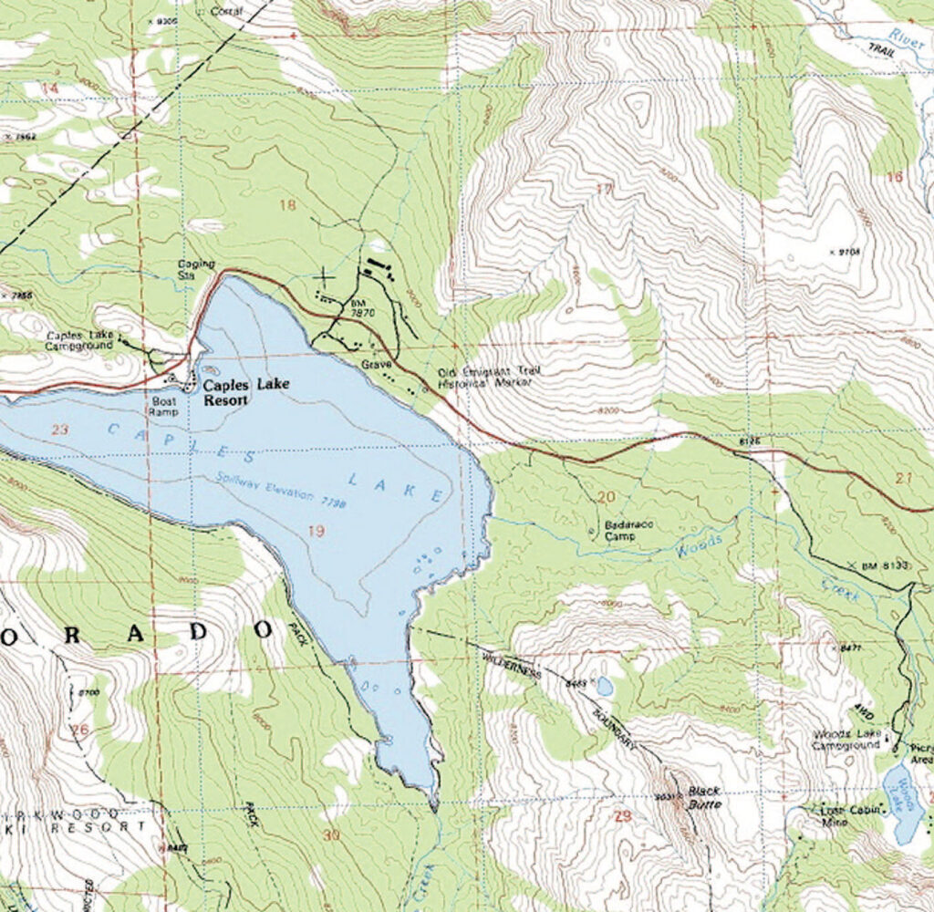
Once you find a stream, you need to know which of California’s 2,850 USGS 7.5-minute (1:24,000) quadrangle maps covers Caples Lake. Fortunately, from either online sources or the California Index to Topographic and Other Map Coverage, you can discover that the Caples Lake quad map, which shows both inlet streams, is the only one required in this case. Without the map in hand, it’s difficult to know whether you also need one or more adjacent quad maps to cover the area.
A review of the topo map shows that Woods Creek has its headwaters at Woods Lake at an elevation of 8,200 feet. (See the USGS topo map on the adjacent page.) The creek is shown as a solid blue line meandering from Woods Lake to Caples Lake, indicating the possible presence of pools and undercut banks. There are two miles of stream between the two lakes, and the elevation drops approximately 400 feet. An access road off Highway 88 is available, and the U.S. Forest Service map for the Eldorado National Forest shows that most of the creek lies on public Forest Service land.
Looking at Google Earth or one of the other computer-based resources that provide an aerial view of Woods Creek shows a mixture of forest and vegetation along the creek, as well as several open areas. This looks to be a promising small stream worth further exploration — after the winter is over, of course.
But this is just an example. Start looking for your own ideal small stream. And remember, when you find it, keep it a secret.
Sources for Government Maps and On-Line Information
If you do any amount of web surfing, you already know that fly fishers can find an impressive amount of angling where-to information online. Resources that are particularly useful for exploring California’s small streams can be found at the following offices and websites:
USGS Western Regional Office — California Topographical Map Index
U.S. Geological Survey
345 Middlefield Road
Menlo Park, CA 94025
Phone (650) 853-8300
http://earthquake.usgs.gov/regional/nca
Bureau of Land Management — BLM Surface Management Maps
California State Office
2800 Cottage Way, Suite W-1623
Sacramento, CA 95825
Phone: (916) 978-4400
http://www.blm.gov/ca
Northern California District Office
355 Hemsted Drive
Redding, CA 96002
Phone: (530) 224-2100
http://www.blm.gov/ca/st/en/fo/Northern_California_District.html
Central California District
2800 Cottage Way, Suite W-1623
Sacramento, CA 95825
Phone: (916) 978-4400
http://www.blm.gov/ca/st/en/fo/central_california/fo-addresses.html
California Desert District
22835 Calle San Juan De Los Lagos
Moreno Valley, CA 92553
Phone: (951) 697-5200
http://www.blm.gov/ca/st/en/fo/cdd.html
California Department of Fish and Game Regional Trout-Planting Schedules
http://www.dfg.ca.gov/fish/Hatcheries/FishPlanting
California Department of Fish and Game Online Fishing Guide
http://www.dfg.ca.gov/fishingpassport/guide.asp
U.S. Geological Survey Website — USGS Map Locator
GeoCommunicator — Site Mapper
U.S. Forest Service Maps for Region 5 (California)
http://www.fs.fed.us/r5/forestvisitormaps/
Google Earth
http://www.google.com/earth/index.html
Dan Sedergren


")