

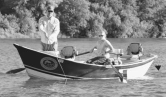
Residents of placer county are blessed with a resource that is unparalleled in beauty and ruggedness and rich in history. The misty-blue canyons of the North Fork of the American River, geologically shaped by uplifting plates and the cutting forces of water, hold secrets and long-forgotten tales that remain unrecorded — tales of original people, hordes of miners in search of the golden Holy Grail, entrepreneurs, ne’er-do-wells, failures, ladies of the night — all this amid grandeur and beauty that both stuns the senses and bestows inner peace. The canyon can be viewed from afar from an aircraft, on Google Earth, or from the road that edges its way from precipitous cliff to deep valley. Or it can be experienced by walking trails, mostly steep and long, but with a few easier grades, deep into remote areas.
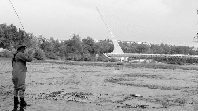
Among the crown jewels of this magnificent canyon are the ancient rivers, streams, and creeks that drain the vast area lying on the north side of the Foresthill Divide, which separates the North and Middle Forks. What follows is a brief description of some of these dark, turbulent watercourses, from their headwaters in high-altitude wilderness lands on down through the canyons of the upper river; how to gain access to them; and the fisheries that they support. I have previously written in this magazine about fishing along the lower portion of the river when the snow flies higher in the Sierra (“Winter Fishing on the North Fork of the American” California Fly Fisher, January/February 2010). I will now describe some of the high-country wilderness trout angling that is available in the summer to those willing to hike the canyon’s trails.
The North Fork American River Watershed
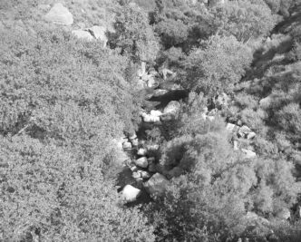
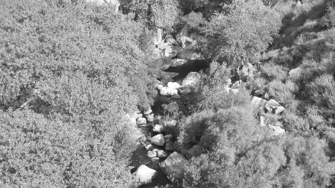
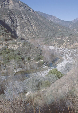
The North Fork rises in a vast expanse of wild, forested lands lying due north of the Granite Chief Wilderness Area and south of the Sugar Bowl ski resort. From there, it falls precipitously into the deep crevasse that is its home, north of the great Foresthill Divide. In this high, remote upper area, the river is formed by a number of small creeks, including Chief Creek, Cedar Creek, Onion Creek, Serena Creek, Wabena Creek, Long Valley Creek, and Palisades Creek.
Below these higher creeks, the river flows from Heath Springs into the Royal Gorge, where it cascades amid cliffs, tumbling in delightful cataracts, falls, riffles, and runs. From there, it continues to be fed from the south by Wildcat, Sailor Canyon, and New York Canyon Creeks and from the north by Big and Little Granite Creek, Big Valley Creek, and others. Downstream, the river is joined from the north by the North Fork of the North Fork and from the south by Humbug Creek, Indian Creek, and Shirttail Creek. The lower portion of the North Fork passes through Giant Gap and its mystical vistas, including Lover’s Leap, past the bridge crossings at Iowa Hill, Yankee Jims, and Ponderosa, and flows into Clementine Lake, a run-of-the-river hydroelectric facility. The river then cascades over the Clementine dam downstream for a short distance, where it meets up with the Middle Fork of the American River at the popular Confluence area. From there, the conjoined rivers, now just called the North Fork, pass under No Hands Bridge, past China Bar, and into Folsom Lake.
North Fork Status Designations
The North Fork, in recognition of its pristine surroundings and extraordinary beauty and remoteness, is classified under both state and federal law as a Wild and Scenic River. The Wild and Scenic River designation commences at the Iowa Hill Bridge and extends upstream to the Heath Springs area, near a privately held enclave known as The Cedars. Pursuant to these classifications, management plans have been developed to protect the resources and values that led to the designation of the river as Wild and Scenic. The river is entirely free flowing from its source down to Lake Clementine. It is at once a kayaker’s dream, with its many class-rated runs and wildly varied terrain, and a hiking and angling paradise for those with an adventurous spirit and the will to endure strenuous, sometimes risky trails. The river also enjoys Wild Trout status from the Iowa Hill Bridge to its confluence with Palisades Creek under California’s Heritage and Wild Trout Program, managed by the California Department of Fish and Game.
These well-deserved designations provide a modicum of legal protection for the resource. Still, there are those who would, if allowed to do so, engage in destructive private and public projects that would adversely affect the North Fork, creating a need for constant vigilance by the numerous nongovernmental groups whose mission is to protect the river, its watershed, its natural history, its flora and fauna and their habitat, and its fisheries. These groups include, among others, Protect American River Canyons, the Friends of the North Fork, the North Fork American River Alliance, the Save the American River Association, and the Foothills Angler Coalition, which includes Trout Unlimited, California Trout, and the Federation of Fly Fishers.

Access to the Upper River
Road access to this upper area is limited to Foresthill Road, which becomes the Soda Springs Road somewhere near Robinson Flat. Foresthill Road begins at the Foresthill off-ramp from Interstate 80, just northeast of Auburn. The town of Foresthill is approximately 17 miles from Highway 80. From there, the road winds up the divide to The Cedars, where it turns north and away from the river, toward Soda Springs. In this article, the road will be called the Foresthill/Soda Springs Road.
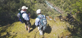
There are a number of trails that provide access to the upper canyon, all of them steep, difficult, and sometimes obscure, but always worth the effort. These include the Tevis Cup Trail, the Western States Trail, the Palisades Trail, the Painted Rock Trail, the Wabena Creek Trail, and a few others. Below the Royal Gorge area, the trails from the north include the Big Granite, Euchre Bar, Green Valley, and Pickering Bar Trails. From the south, the Sailor Flat, Beacroft, Mumford Bar, Dorer Ranch, and Italian Bar Trails provide access to the river. All of these trails are described and depicted in a highly informative book authored by my friend Ron Gould, North Fork Trails: Hiking Trails of the North Fork American River Canyon. (See the sidebar for more information.) This article will concentrate on the five trails that are found on the south (Foresthill) side of the river and divide, plus the American River Trail, which intersects some of them and which follows the river upstream in an easterly direction. Other trails and venues along the river will be the subject of a future article.
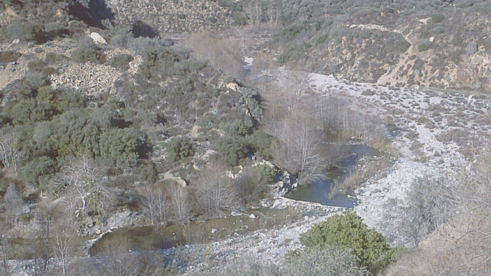
The Sailor Flat Trail is the eastern most trail down to the North Fork, west of The Cedars. To get there, turn left on a rough dirt road located 26.5 miles from the Foresthill Ranger Station on the Foresthill/Soda Springs Road (39° 10.400’ N; 120° 30.455’ W). Follow this road for about 2.5 miles to the trailhead (39° 11.364’ N; 120° 30.07’ W). A four-wheel-drive vehicle is recommended, because the road is rocky, with many water bars. From the trailhead, follow the 2-mile, steeply dropping trail past the abandoned Trinidad Mine and continue down to the river, where the trail intersects with the American River Trail, which follows the river upstream and downstream. Sailor Canyon Creek joins the river a short distance upstream from that intersection, and although it is a little stream, it sports fine pools and runs that are home to small, but eager rainbows that will eat any well-presented size 14 dry fly.
This portion of the North Fork is within the Wild Trout Area and is characterized by classic pocket water, riffles, and runs. Fish it with high-floating dries or with nymphs using a dry/dropper setup or a short-line nymphing rig. Golden Stoneflies in sizes 8 and 10 work well, as do standard mayfly and caddis nymphs.
The elevation drop on this trail is approximately 3,000 feet; the Forest Service rates this trail as “most difficult.” The relevant topographical maps are Duncan Peak and Royal Gorge.
The Beacroft Trail is reached via a dirt road located approximately 21 miles from the Foresthill Ranger Station on the left off of Foresthill/Soda Springs Road (39° 11.581’ N; 120° 34.059’ W). A short distance down this road there is a parking area where the trailhead is located (39° 11.696’ N; 120° 34.059’ W). This steep and difficult 2.5-mile trail crosses the Iowa Hill Ditch, passes a spring, and drops to the river. A fire burned this area badly in 2008; subsequently, there was a large landslide near the base of the trail, which necessitates finding an alternate route down to the river. Once there, find Tadpole Creek a short distance upstream. In wetter years, this creek will have plenty of fishable water with small rainbows. The river here is part of the Wild Trout Area and fishes like the Sailor Canyon Creek area. There are good camping sites downstream from the trail intersection.
The elevation drop on this trail is approximately 2,500 feet; the Forest Service rates this trail as “most difficult.” The relevant topographical map is Duncan Peak.
The Mumford Bar Trail begins at a campground just off the Foresthill/Soda Springs Road on the left about 17 miles from the Foresthill Ranger Station (39° 10.684’ N; 120° 34.348’ W). This popular trail is approximately 4.5 miles long and less steep than the other trails mentioned above. It terminates at the river and the intersection with the American River Trail. The river here is within the Wild Trout Area. More anglers fish here than at the Sailor Flat and Beacroft areas, but the fishing can still be good with nymphs in the pocket-water sections. Another strategy is to swing small streamers through the deeper spots. The fish population is mostly rainbows, but there are also a few sizeable browns lurking about.
The elevation drop on this trail is approximately 2,700 feet; the Forest Service rates this trail as “difficult.” The relevant topographical maps are Duncan Peak and Westville.

The Italian Bar Trail, like the others mentioned above, is an old miner’s trail that leads to the North Fork within the Wild Trout Area. To get to the trailhead, follow the Foresthill/Soda Springs Road about 15.5 miles from the Foresthill Ranger Station. Turn left on Humbug Ridge Road, which is designated as U.S. Forest Service Road 66 (39° 09.482’ N; 120° 39.867’ W).
Follow this road about 3 miles to the trailhead (39° 10.939’ N; 120° 40.629’ W). The trail is steep, winding 2.5 miles down to the river, where it ends at a rock terrace. At the base of the trail there is an old stamp mill and some narrow-gauge railroad track leading back to a mine shaft. It’s probably a good idea to stay out of the shaft.
There is good water for fishing near the base of the trail. A dark-colored soft hackle will produce fish if swung properly. Short-line nymphing water abounds here; use stonefly patterns and the standard array of imitations for mayfly and caddis nymphs. Unlike the trails mentioned above, there is no connection here with the American River Trail. To get upstream for hiking or fishing purposes, it is necessary to bushwhack along the edges. During the summer, this is possible, although there are a few places where a dunking is necessary. The elevation drop on this trail is approximately 2,600 feet. The Forest Service rates this trail as “most difficult.” The relevant topographical map is Westville.
The Dorer Ranch Trail — well, I call this trail the Dorer Ranch Trail, but from the south side, others call it the Euchre Bar Trail, because it connects with a downstream trail (about a mile in length) that leads to the Euchre Bar footbridge. A trail down from the I-80 (north) side of the river also leads to this bridge. Access to the south-side trailhead is via the Elliot Ranch Road, a left turn off of the Foresthill/Soda Springs Road about 12 miles from the Foresthill Ranger Station (39° .07.678’ N; 120° 42.498 W). This is a gnarly dirt/rock road that requires a four-wheel-drive vehicle to navigate it safely. After around 3 miles, there will be a gate on the right; this is where the trail, which is actually the Dorer Ranch Road, begins (39° .09.446’ N; 120° 43.983’ W). Park near the locked gate, because there is no public vehicle access beyond the gate; the ranch road is used by owners/residents living at the bottom of the trail near the river. The trail is approximately 3 miles in length and steepest near the bottom. Near the ranch buildings there is a “Welcome to Dorer Ranch” sign; the home and outbuildings are on the right, situated in a tranquil, somewhat idyllic setting. Just past the buildings, the trail drops to the river, ending at a mining camp adjacent to Humbug Creek, which meets the North Fork here.
The creek supports a decent population of rainbows, and any properly presented size 12 or size 14 dry fly will work, in addition to the usual suspects for nymph imitations. There is abundant pocket water on the North Fork upstream of the creek, along with nice riffles and runs. This part of the river is also within the Wild Trout Area. The fish are mostly rainbows in the 10-to-14-inch range, with an occasional brown in the mix. The same patterns that draw strikes near the other trails will similarly work well here.
The elevation drop on this trail is approximately 2,200 feet; the Forest Service rates this trail as “most difficult.” The relevant topographical maps are Dutch Flat and Westville. Please respect the privacy and property rights of the Dorer family. Stay on the trail, and (as with anywhere else) carry out all of your trash. Seasonally (and this applies to all of the above venues), the spring can produce fast action with stoneflies — nymphs during the day, and dries during the evening — assuming that flow conditions are suitable for angling. During the fall, October Caddis patterns work well — Bill’s Stick Caddis for the larvae and Bill’s Big Fish Fly for the adults. In between, standard mayfly patterns such as Pale Morning Dun and Blue-Winged Olive imitations along with Gray Drake patterns will produce strikes — and, of course, don’t leave home without your ant and other terrestrial imitations. Caddisflies abound in the canyon, so come equipped with your favorites, but be sure to have patterns such as the E/C Caddis and even a hair-wing pattern or two. Searching patterns such as Royal Wulffs, Humpies, Trudes, and other traditional bugs are also effective. Remember, these fish are canyon dwellers that don’t see many flies.
The American River Trail extends eastward (upstream) from Mumford Bar along the south side of the North Fork approximately 7.5 miles. Along the way, it intersects the Beacroft and Sailor Flat Trails. The various maps that depict this area appear to show the trail running right beside the river for its entire length. That is not the case — it is often perched high above the river. Still, there are many places where access to the river from the trail is easy. During lower-flow conditions, there are areas where scrambling along the edge of the river is possible between easy access points. However, unless one knows the river well, there are many good reasons to stay with the trail, mostly related to safety. Suffice it to say that anglers can expect to see very few other souls in this area other than hikers and backpackers.
Precautionary Advice
I hope all these descriptions sound alluring. However, I need to end with some words of caution. Anglers who wish to fish the upper North Fork should consider the venture to be more than a day hike. The trails, while not overly long, are steep. The hike out can be taxing, and during the summer, hot and dry. A good plan would be to hike in and fish for the day, stay overnight, fish a bit the next day, and then hike out. Of course, longer stays are even better if you want to explore the canyon.
Additionally, this year, with the record snowpack and the cool, wet weather of early summer, access to some of the higher trailheads may be difficult or impossible. It would be advisable to contact the U.S. Forest Service office in Foresthill at (530) 367-2224 for updated conditions.
There’s more to keep in mind. Never venture into this area alone; to use a quaint saying, there is safety in numbers, and that applies here in spades. Carry quality energy-source foods — this is no place for junk food. And carry a water-purification device. I prefer filter bottles that can be refilled at will from any water source and safely filter out parasites such as Giardia and other bad organisms. Don’t drink unfiltered water, no matter how clear and clean it looks.
Be aware of the hazards that one typically can encounter in canyons of this sort: rattlesnakes, scorpions, ticks, poison oak, bears, loose rock on trails, and trail washouts. Carry a first-aid kit, a flashlight, a good pocket knife, and other safety essentials.
Plan your trip well in advance, consulting available maps, websites, and other sources of information. Carry a handheld GPS device (and extra batteries) and know how to operate it. It is also advisable to have a compass and topographical map of the area you intend to visit.
Consider purchasing a device such as a Spot unit, which is a satellite-based emergency transmitter that will send an SOS digital message that will result in a rescue helicopter response. In addition to purchasing the device (approximately $150), you will need to subscribe to the service ($100 annually). Still, the rescue flight is paid for, so the benefit is clear.
Consider objectively whether your physical condition is such that this type of activity is feasible and reasonable for you. If you are not in shape, spend the time to get fit before attempting these strenuous trails. There are areas where a trail will pass through private property. Some of these areas are marked, and others are not. Always respect private property rights and “pack it out.”
Take these precautions, but enjoy the overall experience of being in the canyons. The experience includes far more than the fine fishing you will encounter. Each trail has its own unique natural history, wildflowers, historical artifacts, and other values. The trouble (or the joy, depending on your perspective) is that traipsing around these canyons can be highly addictive — and may even lead you to join one of the organizations mentioned above whose mission is to protect the river. In fact, I highly recommend that.
Information Resources
Many websites provide information on the North Fork and its trails. One of the best is a blog site authored by Russell Towle, who was considered the guru of the trails of the North Fork. Unfortunately, Russell met with a tragic and untimely death in an automobile accident a few years ago. His blog is still up and is full of valuable information and perspective: html. See also http://northforktrails.blogspot.com for more information about Russell and his last postings. Other valuable websites include the North Fork American River Alliance at http://www.nfara.org, Protect American River Canyons at http://www.parc-auburn.org, and Friends of the North Fork at http://www.northforkfriends.com.
If you are interested on obtaining a copy of Ron Gould’s excellent book (referenced in this article), along with other valuable information, visit his website at http://northforktrails.com.
Bill Carnazzo


")