I am not a backpacker — I am a fly fisher. I backpack as a means to fly fish. It is just not in my genetic make-up to hike miles and miles past fishable water just for the sake of hiking. I cannot do it. Especially when I see rises.
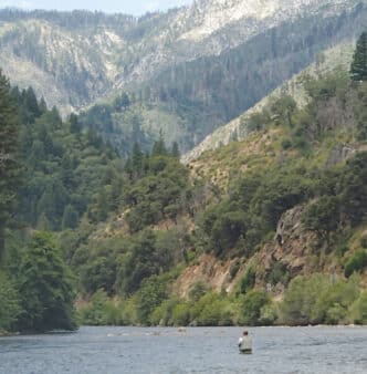
The Forks of the Kern Trail to the upper Kern River in the Golden Trout Wilderness leads to one of those special fly-fishing places that is worthy of all the hassle and effort of backpacking. The “Forks Trail” leads to the confluence of the Little Kern River and the main stem of the Kern River, also known as the North Fork.
My first backpacking adventure was on the Forks of the Kern Trail in August of 2011. My buddy Rudi told me, “If you want to get to the good fishing, you have to earn it with a backpack.” I had no idea what that meant at the time. I know now. Rudi taught me the basics of backpacking and what you need to thrive for a few nights in the wilderness. Since then, I have backpacked the Forks Trail numerous times. I obsess about going there. During the winter, when roads to the Forks Trail are closed and snowed in, I fantasize about it.
I feel like I know the six miles of the Kern upstream from the confluence like the back of my hand. I have had some of the best fly fishing of my life on that stretch, and I have also struggled to catch and release fish. I have even backpacked the Forks Trail to the upper Kern area all alone, fishing multiple 14-hour days without seeing a single other soul. I have shared the experience by leading many to the upper Kern River by way of the Forks Trail, and I’d like to share the experience with you.
Two Subspecies of Trout
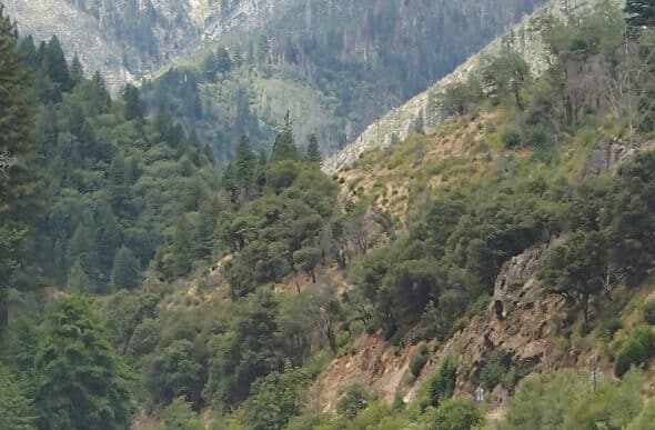
The Kern River is the only major river in the Sierra Nevada range that drains in a southerly direction. With a gradient of 30 feet per mile, the main stem of the Kern River is one of the steepest and wildest whitewater rivers in North America. The “Forks Run,” which is downriver from the confluence of the Little Kern River and the main stem Kern, is a nearly continuous series of Class IV and Class V rapids and waterfalls. Because of approximately 20 miles of rapids, expert-level kayakers cherish the put-in at the confluence of the Little Kern and the Upper Kern. It is rumored that the Forks of the Kern Trail was first blazed by kayakers who dragged their boats all the way down the canyon to the river.
But at the confluence, fishing upriver on either the Little Kern River or the Kern River is manageable for a fit and agile fly fisher. And guess what? You can fly fish for two distinct subspecies of trout that are found only in this area: the Little Kern River golden trout and the Kern River rainbow.
If you are one of those people who are on a lifelong quest to catch as many types of salmonids as possible, the Little Kern golden is on your bucket list. The Little Kern River and its tributaries are the only places in the world that hold the Little Kern golden trout, a unique subspecies of golden trout. For the last four years of drought, these beautiful fish have taken a beating, and I have avoided fishing the Little Kern over that time because the water levels were so low and the fish were so stressed. Biologists have speculated that during the drought, the Little Kern goldens that survived did so by fleeing upstream to the coolest, deepest water. Now that the Little Kern River is flowing well again, all indications are that the Little Kern goldens will come back strong. These fish don’t get big, but you can sight fish for them easily because of their colors, and they fight like hell. They also take flies on top.
The Kern River rainbow is also native, wild, and unique to the area. They get big and mean and will test your fish-fighting skills. Imagine a trout hitting your hopper pattern so viciously hard on top that it scares you. Then imagine that trout going absolutely ballistic after being hooked, jumping 15 to 20 times during the battle and refusing to tire. That is the Kern River rainbow. I have fly fished for trout all over the United States and in many parts of the world, and I maintain that Kern River rainbows fight harder than any trout out there. And because of the wild nature of the river, they are harder to land, as well.
They get big, too; fish over 20 inches reside in the Kern. I have lost big Kern River rainbows by them snapping me off on 5X in midair, for example, and by long runs upriver or downriver at lightning speed. I have even lost them in trees. I had a big Kern River rainbow jump 10 feet into the air into an overhanging tree, snapping me off on the branch on its way back down into the river. But mostly, I lose them because they head shake violently once hooked. I have lost plenty right at my feet. They just don’t give up.
There has been one good thing about the four-year drought: although the Little Kern became too low to fish, the upper Kern became crossable in spots, so that runs on the east side of the river that had been impossible to reach with a cast suddenly became fishable. For the last four years, I have been able to cross the river in numerous places and cast to the risers unimpeded from the middle of the river. However, that party is over, and I can’t imagine there being crossable spots on the upper Kern for the six miles above the confluence until the fall, and maybe not at all this year.
The Fishing
The fly fishing on the Little Kern and Kern can be spectacular. I have had 40-plus-fish days. Of course, as is true on any river, I have had days that are not so good. As on any river, the phase of the moon, the water clarity and level, the weather, the hatches, and the time of year affect the fishing.
The upper Kern can be a nasty, wild, dangerous river in the spring in a nondrought year. Many lives have been lost to drownings on the upper Kern through the years. At the time of this writing in early April, the upper Kern was at 3,500 cubic feet per second. A couple months prior, it was at 10,000 cfs. In June, it is going to be downright dangerous. The upper Kern is not a tailwater river controlled by flows from a dam, and it is always prudent to watch the flow levels. My favorite site is in Kernville, downriver. You’ll find the three-year history very interesting, comparing the present to the drought years. During the drought, I fished the upper Kern many times when the flow was under 200 cfs.
It’s also prudent to monitor the weather over the Internet, especially the temperatures. The closest town is Johnsondale, and it’s not that close, nor is it at the same altitude. But, you can get a feel for the temperature down in the canyon from the weather in Johnsondale. In my experience, it is usually about 10 degrees cooler in the canyon than in Johnsondale because of the breeze in the canyon.
The forks section of the Kern does not see a lot of angling pressure because it’s hard to get to when it’s open and because it’s closed for as many as eight months of the year. This part of the Kern is not for beginners, but I have guided first-timers to success there. There are places with calm water where a tree-free cast can be made. But because the Kern is wild and can rage, getting into position for the right cast can be a challenge. The banks tend to be overgrown with willows, bushes, and other trees. It’s not the type of river for those who hate to lose flies. However, with risk comes reward, and a risky cast flung under a tree and through a two-foot window on a run against the bank is frequently rewarded. However, if my wife and her friend Meredith, both total beginners, can catch fish on dries there, then so can you.

The forks section of the Kern produces the same hatches as many of the rivers of the Sierra, from mayflies, to midges, to a few varieties of stoneflies. What makes the upper Kern area unique, however, compared with most of the rivers and streams in the Sierra, is the abundance of grasshoppers. The Kern River rainbows cannot resist them. Hoppers appear in the spring and get huge by the end of the summer, and I have fished hoppers successfully from early spring through late fall, but size doesn’t seem to matter: I have fished a size 4 Huck Hopper as early as April and absolutely killed with it. The Huck Hopper (see sidebar) is a simple variation that I tie of the Charlie Boy Hopper created by Charlie Craven from Colorado. It does really well on the upper Kern. It floats high, is easy to see from a distance, and does not waterlog. It is one of those patterns that does not look so good in the fly shop, viewed from the top, but that outfishes all the other pretty flies. But I bet any big terrestrial imitation would work on the forks of the Kern all season long, whether alone or as a top fly on a hopper-dropper rig. Unless you are a total beginner, there is no reason to fish nymphs under a “bobber.” The standard rules apply for what to tie on the dropper. Of course, it is always prudent to turn over rocks and stare at the bushes to figure out what is hatching. The general rule of flashy flies in clear water and darker nymphs in not-so-clear water applies.
There are many deep pools on the Kern, so a day spent stripping streamers can be really fun, too. Troutzilla and his buddies live in the upper Kern. More than once, I have had my rod ripped out of my hand by a take on the swing.
Of course, like most of the rivers in the West, the hour at the end of the day can be crazy-fun dry-fly fishing on a size 18 mayfly imitation. For beginners, that is the most likely time of day for easy hookups. I don’t think leaders and tippet size matter much here. I fish 5X in a hopper dropper or pure dry-fly setup and 3X when I strip streamers. You probably can get away with stronger leaders and probably would save a few flies from the trees in the process. In the summer months, I wade wet.
The river is cold — it’s melted snow. But the weather can be hot, so I can be quite comfortable. I always hike in wading boots with felt bottoms. The polished granite stones are slippery. In early spring or late fall, I pack in lightweight waders.
The “Tax”
So, if the fishing in the forks of the Kern is so awesome, why haven’t you heard of it? Why are there so few fly anglers who fish the upper Kern from the Forks Trail? Why doesn’t every fly angler in California fish this section of the Kern? I call it the “Forks of the Kern tax.”
The “tax” is that the hike is physical. You should be in good cardio shape to do this hike. From the Forks of the Kern trailhead, you will lose 1,100 feet of elevation in the first 2.2 miles as you hike down into the canyon to the Little Kern River. That is a reverse hike: you are heavy with food hiking downhill on the way in and lighter on the way out. Then you have to cross the Little Kern River with your backpack, and in non-drought spring conditions, that can be a challenge. The biggest challenge, of course, is that you have to regain that 1,100 feet in 2.2 miles when you hike back out, often with 35 to 50 pounds on your back and frequently in hot temperatures.
The altitude can play a part, too. The altitude at the trailhead is 5,844 feet, so it’s over a mile high. But what really hits you is the heat. It gets hot in the southern Sierra in the summer. It is always best to hike out first thing in the morning, in the coolest part of the day.
Don’t let me scare you off, though. I’m 55 years old and 15 pounds overweight. The huffing and puffing is totally worth it. I brought my buddy Mike from the Diego Fly Fishers on a three-nighter last summer, and he’s 67, six feet four inches, and a biscuit under 250 pounds, so it’s not like a death hike — it’s just challenging physically. He’s begging me to take him back this summer.
I have met fly anglers who do the hike as a day trip, but it is very difficult to do as a single-day excursion. It is an hour drive to the trailhead from Kernville, then an hour to hike down to the river. You fish all day, working your way upstream, then hike all the way back to the confluence, then hike all the way back out at the end of the day, up 1,100 feet. Then there’s the hour drive back to Kernville. That is a very physical day, and consequently, I backpack it.
You’ll need to have the correct permits. You are allowed to have a backcountry campfire in the forks of the Kern, but you will need a fire permit — they are free after you take an online test. Check with the ranger district (phone number below) for any restrictions caused by changing conditions. You’ll also need a permit to stay overnight in the Golden Trout Wilderness. They are free.
Directions: Driving and Hiking
It’s always smart to call the Western Divide Ranger District at (559) 539-2607 before you go. The roads to the trailhead are closed during the winter. Also ask about the flow in the Little Kern River. In the spring of non-drought years, the Little Kern may be too dangerous to cross. I have crossed the Little Kern when it’s raging, but with the help of a rope tied to trees on both sides.
It’s fairly tricky to get to the Forks of the Kern trailhead. The simplest way from Southern California, where I live, is to drive to Kernville and go north through Johnsondale. But, if you’re coming in from the north, driving down to Kernville adds anywhere from 15 minutes (via Highway 99) to 40 minutes (via Interstate 5) to your travel time.
Your basic map app will provide adequate directions to Johnsondale, but I’m going to assume you’re a first-time visitor who would like to stop for information at the local fly shop (the Kern River Fly Shop), which is on Kernville Road after you’ve gone through town and crossed the river.
Continuing east past the shop, turn left (north) onto Sierra Way. You will soon lose cell phone reception and will not regain it until you come back out of the mountains. After about 18 miles, you will cross the Johnsondale bridge. After the Johnsondale bridge, the road name changes to Mountain Road 99 (MR99), and about 3 miles after you cross the bridge, you’ll drive through the tiny community of Johnsondale.
Right after Johnsondale, you’ll pass the Mountain Road 50 (MR-50) junction, where you could have entered from the north or west if you didn’t come from the south through Kernville. The road name changes to NF-2282 here. Reset your odometer or GPS to 0.
At mile 28.4, you’ll find the Peppermint Campground. This is a good place to spend the night if you come in too late or when it’s too hot to hike in, and you want to sleep before hiking in at dawn. Peppermint Campground has running water and a fee for camping (self-pay). The dirt parking lot does have a porta-potty.
At mile 36.2, you’ll see the sign for the turnoff to the George Bush Tree. At mile 36.8, turn right on the dirt road, Lloyd Flat. There is a sign for the Forks of the Kern trailhead on your right. It’s very easy to miss at night.
It’s 2.4 miles on the dirt road to the trailhead. When you get to the end by the trailhead, you’ll be forced into a counterclockwise loop to a large dirt parking lot. Look for the large sign marking the actual trailhead. The GPS coordinates of the trailhead are 36.138538, -118.451797.
It’s 2.2 miles down the switchbacks to the bottom. When you reach the bottom, there is an open, sandy area. Straight in front of you 100 feet is the Little Kern River. It’s tough to cross the Little Kern right there. The sandy trail goes right (south, downriver) or left (north, upriver). To the right about half a mile down is the actual confluence where the Little Kern River meets the Kern.
You want to go left, upstream on the sandy trail, passing two big pine trees to a third big pine tree. This is the easiest crossing of the Little Kern. In drought years, there has been just 8 inches of water — a simple crossing. In big snowpack years in the spring during runoff, it can be a challenge. There has been a rope strung across the Little Kern during many years (including 2016) to help make the crossing easy.
Once across the Little Kern, you’ll be staring at a large, open, sandy area like a beach about 200 yards wide and long. The trail will be barely discernible in this area. Look for footprints. Keep going straight through the sand, and you’ll soon see where the trail picks up on the other side of the sandy area.
The trail parallels the north side of the river for miles. You’ll see many primitive campsites, and there are many more you won’t see.
Fly fishing the upper Forks of the Kern River is not for the faint of heart. But as I have elaborated, there are many reasons that make the huffing and puffing totally worth it. It’s beautiful, it’s remote, its trout are wild and unique. I hope you get to experience the pure joy of the area, as I have for so many years.
For more information, feel free to contact the author via http://fly-fishing-blog.timhuckaby.com.

The Huck Hopper
Hook: TMC 5212, sizes 6-10, or TMC 5262, size 4.
Thread: UNI Big Fly Thread or Ultra GSP thread in white.
“Binder” Strip: 2mm by 2mm piece of foam in any color because it will be covered.
Body: Any color Thin Fly Foam measured to the width of the hook gap: 1mm to 3mm. I like the sparkle foam found at craft stores.
Legs: Light-colored (white, yellow, green, etcetera) rubber legs marked with a black or brown permanent marker.
Wing: Bleached or dyed deer hair in white, red, yellow, etcetera, to match the wing color of the area’s grass hoppers. The Kern has a population of red-winged hoppers.
This fly is based on Charlie Craven’s Charlie Boy Hopper, for which the recipe and tying instructions are found on the Internet at: http://www.charliesflyboxinc.com/flybox/print.cfm?parentID=164.
— Tim Huckaby