
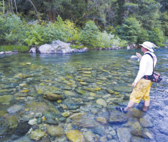

It’s tempting to describe the Yuba River as a typical west-slope freestone stream, since it mostly drains steep granite mountains through deeply eroded canyons. This would be especially true for the South Fork and Middle Fork of the Yuba, which by late summer often become little more than a series of pools linked by diminished trickles. The North Fork, however, fed by many springs, stands out in contrast as a fishery that, during normal water years, provides enjoyable angling into winter. Although the river is not known for producing huge trout, its fish tend to be relatively unselective in their choice of flies. This is a good place for anglers fairly new to the sport of fly fishing.
The North Fork Yuba is not only the most significant branch of the Yuba River, but also the most accessible, since Highway 49 parallels most of its length. It starts at the very crest of the Sierra as two tiny, spring-fed creeks that converge in a small alpine meadow beneath Yuba Pass. This meadow is dotted in season with the blue of lupines and delphiniums, the red of Indian paintbrush, and the white of bogcandle orchids and marsh marigolds, all sustained by water from long-established beaver ponds. The North Fork exits the beaver ponds as a small stream, burbling through shallow pools among alder bushes for several miles before bursting into the top of a steeply falling, rocky canyon below Bassetts. Salmon Creek substantially increases its flow there, and it’s further augmented at Big Springs, where a group of springs bubble out of the side of the canyon and flow under Highway 49.
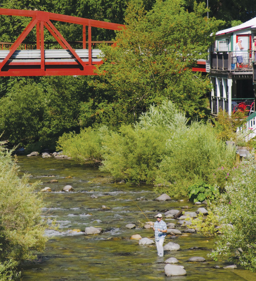
The North Fork then cuts through a narrow slot in solid bedrock and tumbles over Loves Falls. Just above Sierra City, Haypress Creek adds another 50 percent to the flow, and it is here that the North Fork Yuba takes on the characteristics of a true river, pushing through deep pools and heavy pocket water for the 11 miles to Downieville. The river is far below the road downstream of Downieville, most of the way to Goodyears Bar. The elevation changes less steeply, so it becomes more of a pool-and-riffle river flowing through a flood plain. These conditions continue, with the river running adjacent to the highway, all the way to the bridge where Highway 49 crosses the river and starts to climb southward, toward Nevada City. The river continues through a narrower canyon, accessible only by hiking trails, to New Bullards Bar Reservoir. In the headwaters, you’ll find small brookies in the beaver ponds, together with a deeply colored strain of rainbow. In the small stream below the ponds, brown trout start to appear, hiding in the undercuts in the meadow and beneath bushes and next to large rocks in the shallow pools and runs farther down. This section, to about Chapman Creek, gives the fly fisher the chance to catch three species of trout, though few will be over 10 inches.
As you approach Bassetts, rainbows are the predominant trout, and remain so throughout the rest of the river. From Sierra City downstream, they average 10 to 12 inches, with fish of 14 to 16 inches possible. Brown trout are present throughout, some of them very large fish, but they appear to be heavily outnumbered by the rainbows.
Tactics and Flies
All fly-fishing methods will work on the North Fork. Nymphing with an indicator is very successful in pocket water and riffles, but so is fishing attractor dry flies, size 10 to size 16. Try Wulffs, Trudes, or Humpies, depending on which you find in your box. The keen hatch matcher can focus on the pools and often come upon rising fish at some time of the day all season long. Traditional wet-fly fishing also will catch fish early in the season and again on summer evenings when caddisflies hatch. There’s such a variety of aquatic insects, however, that general patterns usually work just as well as specific imitations. The trout might have the choice of several mayflies emerging at the same time, but they’re probably not going to be selective. Nymph fishers also will find their own favorite patterns to be just as effective as anything I might recommend, since in the North Fork’s swirling currents, the trout are opportunists. But if you really need advice, I’d take a Bird’s Nest in size 12 to size 16 against all comers.
One of the hatches I’ve enjoyed on the river is a creamy-orange mayfly, about a size 16, that emerges in good numbers on early summer evenings. This insect is important throughout the Yuba system, and Ralph Cutter kindly identified it for me as Serratella Tibialis, for those who need to know the Latin name. This makes a Light Cahill a good general pattern, and a creamy-orange Sparkle Dun even more useful. Rusty-colored mayfly spinners from size 14 to size 18 fall on summer evenings, joining a parade of various small, pale-colored duns just as the caddises start to hatch, too. Golden Stoneflies are common in the early summer, so carry some size 8 Stimulators and Golden Stone nymphs. The October Caddis hatch may be eagerly awaited, but as on many other rivers, it’s elusive, failing to appear at all on many days. You’ll encounter the greatest concentrations of these large, orange-bodied caddisflies in the upper part of the special-regulation section (see sidebar), but be aware that the water can become very cold by autumn, so fishing will likely be slow if they fail to show.
The Baetis or Blue-Winged Olive hatch is a fairly sparse event on the upper river, but it’s good enough lower down to offer the chance of catching large rainbows on small dries, particularly below the Highway 49 bridge. In my experience, the hatch starts late there, as late as 3:00 p.m., and lasts for about two hours. A size 18 Sparkle Dun is a good imitation. And there are always midges on cool mornings and early in the evenings.
Getting to the Water
As you’ve already gathered, the highway offers easy access to most of the river. There are some stretches, though, where access may be across private land, and it is helpful to refer to the mileage markers that Caltrans erects. The first access (if driving eastward) is where Highway 49 crosses the bridge at the 3.70 mile marker. If you pull out on the north side, you can get to the river downstream. A gravel road behind a locked barrier on the northwest side (marked with a brown sign for Canyon Creek Trailhead) leads a mile to Shenanigan Flat. The water offers good fishing opportunities both upstream and downstream, better than back at the bridge. Fishing is best in the fall, when the water has cooled down. The dirt road continues another mile to Cherokee Creek, a very steep hundred feet above the river. Below Cherokee Creek, a formal trail continues another mile and a half to Canyon Creek.
There are innumerable accesses from the bridge upstream to Goodyears Bar at the 12.30 mile marker, including six campgrounds. This can mean planted fish (although no plants have been scheduled for 2014) and plenty of fishing pressure throughout this section. Even so, numbers of wild fish can still be caught, particularly during the evening rise. If you want to get away from the crowds, you should know that the Yuba River Trail runs along the south side of the river for 7 miles, starting at Rocky Rest Campground (the 5.70 mile marker), where a footbridge crosses the river, and ending at Goodyears Bar. The trail is often high above the river, but subsidiary trails lead down. Back on the main road at the 11.36 mile marker, there’s a trail down to the river.
Upstream from Goodyears Bar, the river is wide open and shallow until the next good access, at the 14.64 mile marker. From here to Downieville, the river is a a bit of a walk from the highway. From Downieville, you can also cross the bridge to the south side of the river and fish back downstream. I haven’t spent much time on the 7-mile stretch from Downieville upstream to Ladies Canyon Creek, since the river is often uncomfortably close to the highway. Pullouts are frequent, though, and the fishing can be just as good as on the special-regulation section, where fly fishers tend to concentrate. This starts at Ladies Canyon Creek (at the 24.80 mile marker) and runs to the western boundary of Sierra City. The river is soon well below the highway, and accesses are fewer. Just past Fournier Ranch (the 26.00 mile marker) there’s a pullout where you’ll find a steep trail down. A trail also leads down to the river from a parking area near the 27.30 mile marker. At the Forest Service’s Loganville Campground (the 27.70 mile marker), you can park off the road and walk through to the river. The final access to the special-regulation section is down a track to the left of Herrington’s Sierra Pines Resort at the 28.80 mile marker.
Through Sierra City to Haypress Creek, the water is much the same as it is in the special-regulation section, but you may run into planted fish and some bait-fishing pressure on the weekends. Above the bridge at Wild Plum Road (at the 29.90 mile marker), you’ll find steeply falling pool-and-pocket water that provides angling for rainbows to 12 inches. The narrower sections around Loves Falls are tough to fish, but can be accessed by walking the Pacific Crest Trail, which crosses the highway at the 31.20 mile marker, down to the river. Access is pretty easy from Bassetts upstream, since the much smaller stream is usually close to the highway. The fish may be small, but the surroundings are lovely, as tiny meadows and wildflowers alternate with the dense alders and log structure. The beaver ponds at the top can be reached by parking in a pullout at the 40.22 mile marker and walking back down a diagonal track into the meadow.
Angling Options Nearby
The North Fork Yuba’s tributaries also offer opportunities to catch trout on flies, although because these streams are smaller than the mainstem river, the fish tend to be smaller, as well. I’m going to focus on two streams, Lavezzola Creek and Pauley Creek, both of which are arms of the Downie River that joins the North Fork Yuba in Downieville.
The deep canyon of Lavezzola Creek is initially separated from neighboring Pauley Creek by a narrow, forested ridge interrupted by gaps called “Divides” that carry the dirt road that winds upstream to Lavezzola Ranch and that give us our landmarks. Almost unique among small Sierra streams, it’s designated by the state as a Wild Trout water. The headwaters of Lavezzola Creek are a long way from any road, though a trail does follow it. The middle section can be reached by a short hike, and you can even park at the bridge at the Second Divide and fish right there. Occasionally you might spot a trout, but mostly you’d swear there were none present. Then you make a cast, and a trout comes from nowhere, like a conjuring trick. In the fall, the water gets very cold, and the hatches contract to midges and more midges. Then you can spot fish holding in smooth runs and tailouts, and tiny dries or midge pupae will catch them.
To reach Lavezzola Creek, take Main Street north from Downieville to Hospital Bridge across the Downie River. The road bends left, then you take a fork right onto Lavezzola Lane, a good dirt road going uphill. In 1.5 miles, you’ll come to the First Divide, from which you can see into both Lavezzola and Pauley Creek canyons simultaneously. There is a chain-link fence and gate on your left, and if you walk around that, an old miners’ road will take you upstream for about half a mile before it drops down to the creek. You can’t fish upstream very far before some rock climbing becomes necessary, but faint miners’ trails go downstream a long way on the south bank, then continue on the north bank. If you stay on the road for 1.3 miles, you’ll cross a bridge and can fish either upstream or downstream. The parking area for the Third Divide Trail is 0.7 miles from the bridge, while the trailhead is on Empire Ranch property, a quarter of a mile up the road. The trail crosses Lavezzola Creek on a sturdy footbridge, and you can fish upstream or downstream.
Pauley Creek flows into the Downie just below Hospital Bridge. It forms from small streams and springs in broad Gold Valley, then falls quite steeply through a narrow canyon before slowing down a little after Butcher Ranch Creek joins it, substantially increasing its flow. Here it flows southwest through an old-growth forest, then again through a narrow canyon westward to the Second Divide, where it turns to the south again and flows roughly parallel to Lavezzola Creek. The lower canyon is rather different to Lavezzola’s, being a little drier, its slopes cloaked in oak and manzanita, as well as in fir trees, and its pools deep and steep-sided. As with Lavezzola Creek, the fly pattern you fish seems fairly unimportant. The premium is on predicting where the fish might be and making an accurate cast, the first one always giving you the best chance of success. The first access is just across Hospital Bridge, where a trail goes to Pauley Falls, just behind the PG&E substation. From there, you can also hike the new First Divide Trail, completed in 1997, which runs high above the creek to join an old miners’ road that starts at the First Divide, opposite the chain-link fence. From both trail and road, faint trails lead down to the creek. If you drive Lavezzola Lane for 2.4 miles, you’ll come to the Second Divide Trailhead. Park there and hike the trail for just over a mile to a Y junction. If you stay right at the junction, the trail drops downhill a third of a mile to an old miner’s cabin, with good water upstream and downstream. Some minor rock climbing may prove necessary through here. If you stay left, the trail gradually drops closer to the stream at various points as it approaches the Third Divide Trail, but that is 4 miles from the trailhead. You could reach that point a little quicker on the Third Divide Trail itself, just over 2 miles from the trailhead, or from Butcher Ranch Creek, the shortest hike, but also the steepest.
The Regs
The North Fork Yuba is open year-round from the western boundary of Sierra City downstream to New Bullards Bar Reservoir. From November 16 through the Friday preceding the last Saturday in April, all fish caught must be released, and only barbless artificial lures can be used. During the general season, from the last Saturday in April through November 15, the stretch between Sierra City and Ladies Canyon Creek remains artificials-only, although two trout can be kept, and the rest of the river has a five-fish limit with bait allowed.
Stephen Rider Haggard


")