
Something woke me in the early morning gray — the sound of water splashing and the click of disturbed stones. There, at the confluence of the Iron and East Fork, a band of bighorn sheep were crossing the stream, five ewes and two rams. One ram stood as sentinel while the others crossed, its back to the stream, facing the sycamore stand where I watched from my sleeping bag, holding my breath. The great whelked curls of the ram’s horns seemed made of sun-hardened stone — stone of that forgotten desert from which their kind were secretly birthed. They grazed quickly into a bank of alders and then up through the topmost stand of live oaks lining the bottom of the canyon, disappearing into shadows and then appearing again farther on, entrained across a patch of barren ground upslope, obscured among the scrub oak and spiked sotol.
The bighorn crossed at the tail of a run from which I’d turned at least a dozen wild rainbows the evening before. Bright leaves of trout. Descendants of southern steelhead landlocked with the construction of Morris Dam in the late 1930s. And yes, before the dam, there were salmon, too, ascending a San Gabriel River once flowing unobstructed down from the mountains and over the wide semidesert coastal plain, at the time of the dam’s construction well on its way to becoming one of the most populous regions on earth. Though salmon and steelhead from the sea were only ghosts when I first came to fish in 1964, the wild rainbows were still there. And they were there on the morning of the passing sheep, at the confluence of the Iron Fork, when I camped beneath the canyon sycamores in 1975, the last time I’d fished the East Fork.
Avoiding the freeways, I didn’t hit a single green light driving the grid of surface streets to Azusa from my sister’s place in Hacienda Heights. The sprawl of stucco housing tracts looked worn behind the graffitied walls and fences. Driveways and roads choked with vehicles. Traffic. I tapped the steering wheel, waiting for another red light to change, my eyes on the hazy cordillera rising abruptly beyond the grid of high-tension wires.
The mountains are a refuge. The long blue sky above the smog line.
The canyon of the San Gabriel was as I remembered it. Stark, angular, impossibly steep. The water in the reservoir behind Morris Dam was the color of cement. I recalled that a large portion of the East Fork drainage had burned a couple years ago. There hadn’t been enough rain to bring the ash down. Then the drought broke three weeks prior to my return, and an unusually heavy rain in November brought the ashy silt flooding down from the burned slopes. Ash contains lye, and I wondered if there was anything still alive in the reservoir. It had once held large rainbow trout that spawned up the forks like steelhead during the winter months.
On the East Fork Road, approaching Camp Williams, a tongue of fire had burned down a draw to the road, leaving nothing but the crumbling black skeletons of scrub oaks splayed above the scorched mountain caliche.
The Sheep Mountain Wilderness Trail heads at the end of the road. Where there’d been only gravel-shoulder parking forty years ago, there is now a paved parking area with restrooms. The restrooms were trashed, one of the doors busted. I counted ten vehicles parked there, a good deal more than what you’d encounter forty years ago on a weekday in November. The camo-painted pickup, I later learned, belonged to an itinerant gold dredger living and working up the canyon. I also learned that placering is forbidden on the East Fork, yet the recreational gold crowd, grown considerably nihilistic in recent years, is engaging in open protest, disregarding the East Fork’s hands-off status and, apparently, getting away with it. Historically, the stream’s gravels don’t bear much gold — nothing, really, weighed on the balance against the loss that extraction creates.
The East Fork comes down through a narrow fissure in the mountains. Immense boulders shaken from the almost vertical slopes during earthquakes graze the canyon floor like great beasts. A mile in from the trailhead, alders lining the creek are still heavily tattooed with carved graffiti. Some bear no art but the rude scars of random hatchet blazes, as if the tree hackers were mindlessly testing the blades while passing. Here and there, would-be lumbermen waxed more ambitious, leaving canyon alders hacked all the way through and fallen.
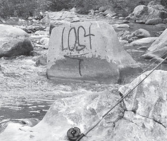
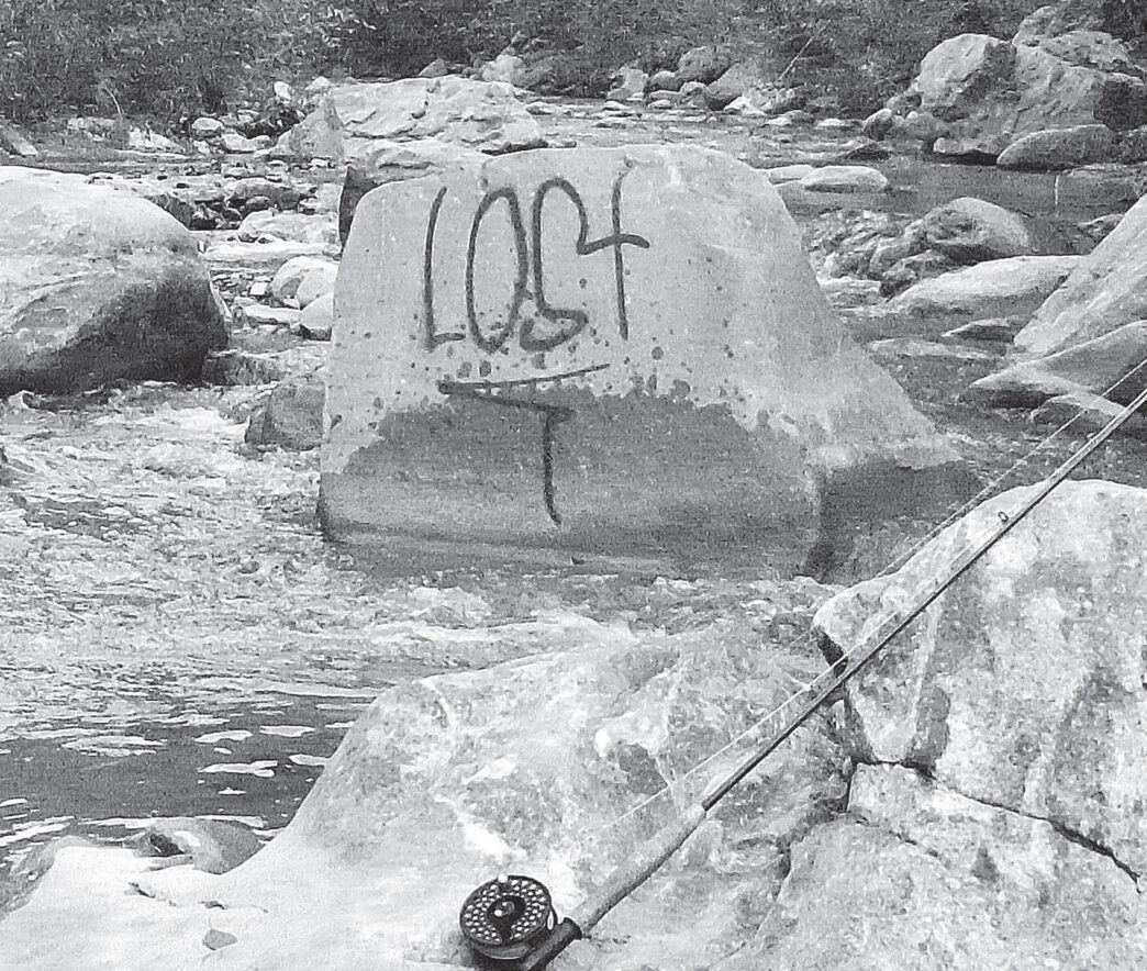
About a mile and a half up the trail, I came to a crossing where my foot sank into a drift of soft, gray silt. The stream had a milky hue; the silted waterline showed how much the water had risen during the flood. Everything below that watermark was buried beneath fine, concrete-gray silt. At the crossing, a large stone loomed midstream. A graffiti artist had spray-painted the word “Lost” on its face. Nothing else, simply: Lost.
I hiked upstream for another two hours, noting the places where gold seekers had altered the stream course. I passed a row of riparian alders undermined to the extent that the trees had fallen over into the stream. Piles of trash, plastic buckets, and pieces of broken equipment littered the creek banks. I found a portable aluminum sluice box that had somehow been smashed flat. The ruined sluice had a Bassmasters sticker plastered to it, and I thought it strange, the sticker, and wondered about the correlation.
Three hours in, it was time to fish my way back out. I tied on a size 12 Partridge and Peacock, heavily weighted under the body. In 1975, that fly had turned more than thirty wild trout, fished down that same length of stream. But this was a different day in a distant year. Not long into it, the void feeling that comes when I know I’m casting over empty water began to occupy me while I fished, dissolving my enthusiasm.
When I arrived back downstream at the “Lost” rock, I quit fishing. I hadn’t had a single take and saw no sign of life within the stream — no fingerlings scooting for cover when I troubled the water.
While I was changing out of my wading shoes, getting ready for the hike out, a compact brown man carrying an alder hiking staff came down the trail and stopped. Guy about my age, his short-cropped black hair turning gray. He wore 501s and a clean wife-beater undershirt, his exposed arms entirely inked. A permanent blue teardrop on his left cheekbone indicated he’d been a hard-timer, though his quality hiking boots and daypack hinted another facet. Wiry, in good shape. I took him to be a regular on the trail. Perhaps a cholo ex-con from the seething neighborhoods down in the valley, one who’d found peace up in the canyons. A fetching Indian girl rode his upper arm. Maybe he was a Gabrieleno, descended from the people who once inhabited these canyons. Perhaps, I mused, he was a remote grandson of the great Toypurina, the native woman who rose to organize a desperate rebellion against the San Gabriel Mission Spanish in 1785.
“You catch any fish?” he asked.
“Nah,” I shrugged, “Doesn’t seem like there’s any fish in the stream.”
He nodded his head. “There was. But the rain a few weeks ago flooded the river with that gray silt, and it killed the trout. I was up here right after the rain, and there were dead trout everywhere. Some big ones. You used to see them in the water. But I haven’t seen any since that. I think all that stuff from the fires coming down might have killed them.”
I watched the hiker disappear down the trail. Lost. Was that graffiti scrawled on the stone prophetic? I hoped it wasn’t so. Something brown flashed in the periphery of my vision, and I turned to catch a water ouzel dive into a plunge pool beyond the stone.
About a half mile from the parking lot, the clack of falling stones stopped me on the trail. Two magnificent bighorn rams picked their way over a rock slide, ghosted through a cluster of sotol, then crossed the trail a hundred feet in front of me. The wild sheep seemed incongruous, ranging the apocalyptic creek bed. I stood still, holding my breath, hoping the sound of my heart banging against my rib cage would not alarm them. They grazed their way toward the stream, big animals, much larger than a deer. I was downwind. When they’d moved off enough, I knelt and slipped the camera from my daypack and stalked them, trying to get some pictures. Nervous, edgy, they kept moving, always keeping to the shadows and brush offering them the most obscurity and least opportunity to be photographed. I managed a few badly focused shots.
At the parking lot, I was stowing my gear when the bearded prospector, camoed to match his pickup, emerged from the trail. He threw his pack into the bed of his rig, pulled a beer from a cooler, opened it, and drifted over my way.
He hailed me with the beer bottle. “Catch anything?”
“No. Not today,” I said.
He went on to tell me he’d been staying “up the narrows,” looking for gold, trying to earn enough for gas to get to Alaska, “where the real gold is.” He’d witnessed the fish kill, too, his story matching that of the hiker I’d met.
“Bummer about that. Used to see them all the time, but no, I haven’t seen any trout in the creek since the rain brought down that silt,” he said.
Young, dynamic, the San Gabriel is the fastest-growing mountain range in the world. The cordillera is raw, loose, and scarred with cataclysm. Close proximity to one of the largest population centers on earth makes the San Gabriel particularly vulnerable to human activity. The geography is formidable, yet most of its gems are accessible — the secluded stands of big cone fir and giant sugar pine, the watersheds — and these require nearly constant stewardship. It requires attentiveness to maintain the integrity of a remnant native trout fishery contained within a small, easily accessible creek like the East Fork, so close to the Los Angeles basin. In 1975, there were riverkeepers. Almost daily patrols of friendly, backpacked Forest Service rangers hiked up the East Fork canyon, keeping an eye on things. Since that time, shifted priorities and steady budget cuts have resulted in fewer patrols, less stewardship, and increased degradation of the San Gabriel watershed.
Concerned-citizen groups and regional leadership activated, and on October 10, 2014, President Obama used his authority under the Antiquities Act to set aside 346,177 acres of public lands in the Angelus National Forest as the San Gabriel Mountains National Monument. The sensitive San Gabriel River drainage above Morris Dam is included. The idea and hope of national monument status is to ensure increased stewardship monies and resources, as well as volunteer activities within and around the periphery of the monument.
I’d like to predict a bright future for the wild trout of the East Fork, even if that future waits beyond my lifetime. Any positive result of the newly conferred national monument status was nowhere evident at my return to the East Fork, a month after the president’s signing. Of course, it’s too soon to tell. Still, special status labels have been applied to the San Gabriel River in the past — it’s a Wild and Scenic River, and the East Fork, ironically, is listed as both a Wild Trout Water and a California Heritage Trout Water — yet I returned to find the East Fork in a seemingly hopeless state, with the effect of illegal gold placering, alone, astonishing. Maybe things will change for the better, given enough time. There’s no gain in losing hope. The water ouzel and the bighorn sheep are still there, and the trout of the San Gabriel have survived other cataclysms down the millennia, their kind secretly holding out by their own design, oblivious to ambiguous status.
I returned to the San Gabriel again, on December 30, 2014, the barometer steadily falling as a cold front moved in. The front, bringing much-needed rain, would drop rare snow on the southern valleys the following evening. Though foreboding cold winds gusted up the canyon, bringing rafts of yellow and brown leaves showering onto the stream, the morning was fishable. I noticed right away, the West Fork gets more loving care than the East Fork. Gone are the graffiti that used to be so prevalent near the parking area. Also gone are the rock-dammed swimming holes people used to build there. The stream bank seems more lush than it was when I last visited, in 1975, the alders heavily inscribed with healed glyphs, yet healthy and free of the destructive axe work evident at the East Fork. But like the East Fork, the streambed of the West Fork downstream of Bear Creek was filled with the gray silt brought down from the burned slopes of the Bear Creek drainage.
Bear Creek is a tributary of the West Fork. In the early 1970s, it hosted an abundant population of wild rainbows. I’m not sure how that’s doing now. I hiked up a few miles and found the riparian habitat in better shape than it was in those years, the trail defined and tread installed farther back from the creek. As with most of the San Gabriel, fishing Bear Creek is a roll-cast and dunk affair. A size 12 Partridge and Peacock, weighted under the body, used to be the ticket. But not on this day. The streambed was silted, though not as heavily as the East Fork. I concentrated on the best-looking water, fishing my way back down to the confluence, yet didn’t turn any fish or see any sign of life within the stream.
Back at the confluence, I hiked up the West Fork for a mile. Above the confluence with Bear Creek, the stream was a healthy tannin color, and the bottom gravel was free of the gray silt. Between rains, the West Fork was as low as a brook and choked with leaves. I didn’t fish, just looked around the fly-fishing-only segment. The West Fork no doubt still harbored the wild seed needed to replenish the damaged tributaries. The wind up the canyon turned colder and more insistent. I hiked back down to the pickup. While I was putting my gear away, the rain started to hit.
Postscript
The story of the San Gabriel River continues. Will the new national monument status help to alleviate the problems confronting the San Gabriel? Time will tell. In any case, I think it’s going to require citizen users taking an active role in defining what they would like to see happen in the new national monument. Though my hat is off to what few active friends the San Gabriel River has, there are currently not enough (based on this visitor’s observations) to oversee those things that need to be done to stop the ongoing degradation of the river canyons. Perhaps the fly-fishing clubs of Southern California will see national monument status as a worthwhile lever in achieving catch-and-release regulations and habitat improvement for the entire San Gabriel system within the national monument. Even if nothing has happened yet, the new status does create enticing possibilities worth exploring.
— Steven Bird


