As I travel through the Sierra, I often think about the early explorers who visited the range. I marvel at how difficult it must have been to find their way through new terrain, day after day, seemingly always in the winter, without benefit of reliable information. Looking at the Sierra Crest, I try to imagine what it would be like to try to locate a route across the summits through a landscape I had never seen or had described to me.
One such trip was made in November 1833 by a party led by Joseph Walker. They had made their way south through the Carson Valley, seeking a means to cross the Sierra. Francis Farquhar describes this trip in his classic History of the Sierra Nevada. The expedition followed the East Fork of the river that is now named for Walker, reaching the headwaters. They were dogged by snow and diminishing provisions. Somewhere in the headwaters area, they crossed the river, and the party reached the ridge that separates the drainages of the Merced and Tuolumne Rivers. Along the downslope, part of the group scouting a route was stymied by a series of cliffs. Peering over the side, they gazed into a mile-deep chasm carved from sheer rock walls. The explorers were looking into Yosemite Valley.
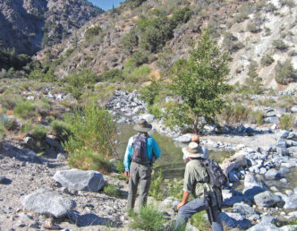
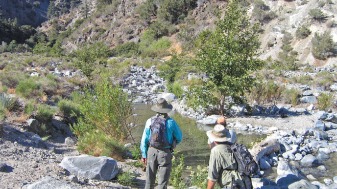
The Walker journey can be approximated by way of the Virginia Lakes trailhead. The trailhead is reached by a side road leading west from Highway 395 at Conway Summit, about halfway between Bridgeport and Lee Vining. In the fall, the summit draws throngs of photographers and fall-color enthusiasts taking in the broad expanses of aspens and willows. Although I have not found a definitive statement of the route taken by Walker and his men, the Virginia Lakes drainage qualifies as the headwaters of the East Fork of the Walker, and the relatively smooth ascent to the Sierra Crest and then down to the Tuolumne suggests that this may well be the general area in which the men traveled. It’s a way to access both amazing scenery and good high-Sierra fishing opportunities.
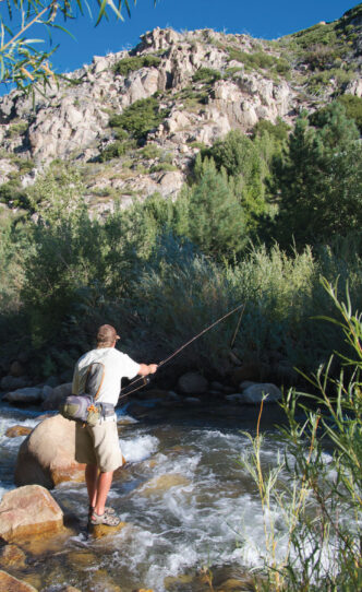
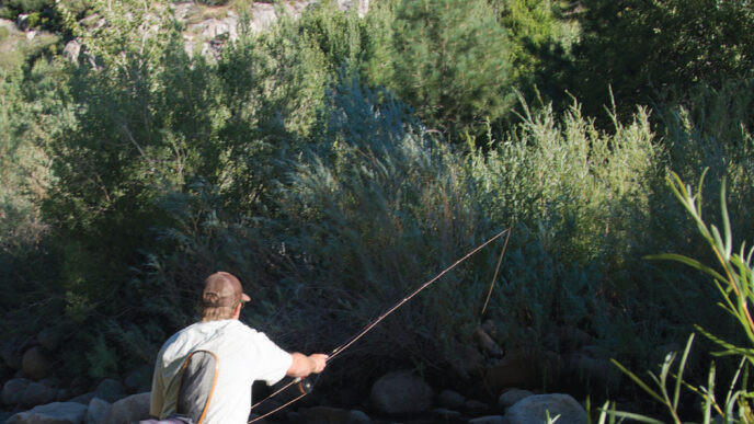
The Virginia Lakes Road, which ends at the Virginia Lakes trailhead, is paved and parallels Virginia Creek. The stream can occasionally be glimpsed in the deep valley to the left of the pavement. As the road leads toward the rock wall of the Sierra Crest, numerous areas of deadfall give evidence of winter avalanches. The creek itself offers dry-fly opportunities for the angler who is willing to do a little work. There are a couple of access tracks, and a campground is located in the canyon. Otherwise, to reach the creek you have to scramble down the hillside from the road.
On one of my first trips to east side of the Sierra, I dropped down to the creek on a crisp October day as the sky gave way to gray overcast and ultimately to snow flurries. I spent my time probing a series of plunge pools and swift water sections. The creek is small, especially in autumn, and runs through a tunnel of willows along its entire length. Presentation mostly consisted of downstream drifts made by dropping the fly into the current, rather than by actually casting. Rainbow and brook trout both responded to a well-placed offering. Just as it became clear that I was risking overstaying my welcome in the weather, a brilliantly colored brook trout became the largest fish of the day. I was hooked on the eastern Sierra.
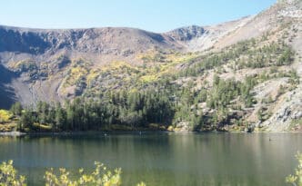
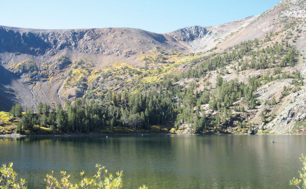
Three lakes are located at the end of the Virginia Lakes Road: Big Virginia, Little Virginia, and Trumbull. A campground is located there, as well, as is the Virginia Lakes Resort, which offers cabins, a café, some supplies, and boat rentals. All three of these lakes sit in scenic rock bowls and hold brook trout, rainbows, and the occasional brown trout. They are heavily stocked and heavily fished.
Trumbull is a small, 12-acre lake that is said to be the home of some large fish. I use this phrase because you could not prove this by my experience — my history at Trumbull does not feature much in the way of success. The lake is surrounded on two sides by a broad, grassy meadow that displays a profusion of wildflowers in the early summer. There are willows and trees at the lake’s edge, but also open areas that allow casting. The other two sides of the lake back up against steep rock faces. All three lakes are popular with float tubers, and nonmotorized boats are permitted.
I am always confused about which lake is Big Virginia and which is Little, so I think of them as the upper and lower lakes. The lower one is next to the resort and is separated from the upper lake by a low, rocky ridge. They are both nestled in a stark bowl formed by brightly colored red, gray, and black rock. I almost always fish the upper lake.
This lake is much deeper than Trumbull or the other Virginia Lake, so it is a better bet in midsummer. The shoreline is open, offering easy casting. A bit of rock scrambling is required to work your way completely around the lake. During the day, with Matukas, Woolly Buggers, or other streamers or with Copper Johns, Pheasant Tails, or other nymphs. Early morning or the last hour of daylight bring fish into the shallows, and they can be taken with dry patterns such as Cutter’s Perfect Ant, the Elk Hair Caddis, Humpies, or a Parachute Adams. I like to visit this lake during one of these rise times before setting out on the trail or at the end of a backcountry ramble.
The Virginia Lakes Trailhead
The Virginia Lakes trailhead is found at the parking area at the upper lake (elevation 9,670 feet). The trail takes off to the right, just past the restroom area. A lateral also connects the Trumbull Lake Campground to the trail. Travel options include a variety of day hikes to one or more of the many high lakes, an easy overnight connection with the Green Lake trailhead, or a multiple-day trip over the Sierra Crest into the north boundary area of Yosemite. Overnight trips, especially those into Yosemite, require permits. Contact the Toiyabe National Forest or Yosemite National Park for information before heading out.
The trail starts with a short uphill hike through trees and then levels off. A few minutes of walking lead to a small creek and ponds that provide dry-fly fun, fishing for small brook trout. Leaving the ponds, the trail climbs and traverses a talus field to Blue Lake (9,740 feet). Blue Lake is a small body of water holding brook trout and some rainbows. I have visited this lake many times, but my fondest memory involves finding a couple of cold beers washed into the outlet stream below an unoccupied campsite on a hot summer afternoon. The trail follows part of the shoreline, but you can get away from the many hikers by simply walking farther along the shoreline. A panoramic view looks down Virginia Canyon, with its multicolored volcanic rock. Most likely, your
casting location will be determined by the direction of the wind, especially in the afternoon. My most recent trip to Blue Lake produced bright, spotted brook trout that eagerly took several different dry-fly patterns. It was the first day of October, and the last hurrah for fall colors. I had the lake to myself for more than two hours once I moved away from the day-hiking traffic on the trail. The trail is heavily used, but almost everyone is simply out for a hike.
Above Blue Lake, the trail makes a traverse of Dunderberg Peak. Avalanche scars testify to midwinter drama there. At the top of the traverse is a moderate stretch through a small meadow that is dotted with columbines and shooting stars early in the year. A lateral trail leaves to the right, following a willow-lined stream. The trail junction is marked, but is easy to miss. This trail climbs steeply to Moat Lake, which is said to contain golden trout, but my visit did not leave me in a position to verify this. Perhaps I should have picked a day without a continuous gale-force wind. Crossing the meadow, the main trail rises through whitebark pines, crosses a ridge, and arrives at Cooney Lake (10,100 feet). Cooney features a dramatic outlet stream that tumbles over and down the rocky slope you just climbed. The outlet simply begs to be fished, as does the vegetation-choked inlet. The entire lake is open, though, and casting is generally easy for rainbows and brookies. Another 200 feet of altitude gain puts you at the three Frog Lakes, which stair-step between 10,350 feet and 10,375 feet. The lakes sit in a tundra basin. All of them contain brook trout, as does the connecting waterway. A walk up the Frog Lakes bench is a great way to spend a few hours with a dry fly. This is a chance to experience fishing in a true alpine setting with an investment of less than 700 feet of altitude gain and fewer than three miles of walking. The path, while continuously uphill, is not overly strenuous by eastern Sierra standards. You certainly do not need to carry a lot in the way of equipment: a light rod and a dozen or so dry flies is all you need. I would bring Cutter’s Perfect Ants, some Parachute Adamses, Royal Wulffs, Elk Hair Caddises, and Humpies in sizes 16 and 18. This is not challenging fishing, just fun. The setting is the draw, with really interesting geology, wide-open tundra, and the sounds of mountain chickadees or the whistle of a marmot or pika.
To Green Lake
Those with a couple of days at their disposal can follow the trail leading beyond Frog Lakes to connect with Green Lake. The trail from Virginia Lakes to Green Lake can be done as an ambitious day hike, but this would not leave much time, if any, to experience the fishing, so do it as a backpack trip. That will require a vehicle shuttle between the Green Lake and Virginia Lakes trailheads. The trip can be made in either direction, but the altitude gains are much less severe if you start out at Virginia Lakes. The trail crests a divide at 11,100 feet and drops quickly into the basin that holds Summit Lake. This is Summit Pass and is 2.7 miles from the Virginia Lakes trailhead. Follow a series of switchbacks to a trail junction. At this point, you are about four and one-half miles from the Virginia Lakes trailhead. The junction is marked to Hoover Lake and Green Lake and is found shortly after the pass. Take the trail to the right, which drops steeply downhill through rafts of wildflowers in season.
It is a short, but quite steep hike down to Upper Hoover Lake (9,840 feet). The deep descent makes one wonder why anyone would hike this route from the Green Lake trailhead. The trail runs above Upper Hoover Lake and then crosses between the Hoover Lakes. There is often snow in this bowl late into the summer. The Hoover Lakes hold brook trout. The trail continues to traverse the slope, drops quickly downhill, and crosses the forested slope above Gilman Lake (9,509 feet). Gilman holds brook and rainbow trout. Hoover and Gilman Lakes abut Kavanaugh Ridge and Dunderberg Peak, and their setting is dramatic. As mentioned, the trail runs above these lakes, so to gain access to the shoreline you need to hike down steep slopes.
A descent of three-quarters of a mile takes the hiker to East Lake. This deep blue body of water occupies 75 acres in a rocky basin backed by Grabbo, Page, and Epidote Peaks. The gray, red, and black rocks are evidence of the volcanic origins of these peaks and contrast with the iconic Sierra granite. There are several campsites at the lake outlet and along the north shore of this popular destination. East Lake is often used as a base camp area for exploring Hoover and Gilman, due to its relative ease of access.
The trail continues toward Green Lake by crossing the East Lake outlet and then dropping steeply down a forested slope to a point where it reaches a trail junction. At this junction, one can proceed west to West Lake or continue on the marked route to Green Lake (9,000 feet) by descending across a dry slope. Green Lake, which is slightly smaller than East Lake, is likewise a popular destination owing to the fact that it is only a short distance from the Green Lake trailhead. The 50-acre lake is surrounded by forest, with rocky areas to the west and southwest. There are several good campsites in various spots along the lakeshore. Green contains rainbow and brook trout.
After crossing the Green Lake outlet, the trail heads for home by climbing a series of switchbacks over a rock ridge. From the ridgetop, the last length of the journey drops through a forest rich with mule ears, serviceberries, Western blueberries, lupines, paintbrushes, shooting stars, columbines, and penstemons in season. The trailhead is found at a pack station at the end of the Green Creek Road.
The East Lake Junction
Back on the trail at the East Lake junction above Frog Lakes, if you bypass the trail to East Lake, you are on the way to the northern boundary area of Yosemite, and those who want to spend a few days can continue on into the park. The Summit Pass landscape there is one of the more compelling in the range. The feeling of the tundra surrounded by multi-hued jagged peaks really conjures up the notions of wide open and wild. The views down into the lake basins beneath the pass are truly dramatic and memorable.
Not far from the East lake junction, a steep downhill path leads to Summit Lake (10,200 feet). Summit Lake is unique in that its two outlets drain to opposite sides of the Sierra Crest. Summit Lake contains rainbow trout.
Moving past the lake, the trail follows Return Creek into Virginia Canyon and crosses the national park boundary. The trail parallels the creek for five miles to a junction with the Tahoe-Yosemite (Pacific Crest) Trail. There are campsites along this stretch, with a well-used area at the junction itself. I imagine a lot of people lay over here and fish immediately above and below the ford as a quick end or beginning of a day of hiking. Below the trail junction, the creek falls away from the trail, and this is a spot for more secluded angling.
Return Creek is one of my favorites. It has a significant population of active rainbow trout. The stream flows through terrain in which it has carved a beautiful series of pools out of rock formations — ideal for a bath. Forest surrounds the creek. The fishing is easy, making this a great place to bring a beginner. On one of my first trips to Return Creek, my wife and I were with a friend who was just learning to fly fish, and he was able to experience a lot of positive reinforcement. For us, the smiles on his face were the perfect cap to a day spent listening to birds, checking out the Yosemite wilderness, and casting dry flies to the many trout.
If you take the trail fork north from the Return Creek crossing, you are on the way to Matterhorn Canyon and the heart of the north boundary. (See “Two Trips for Yosemite Wilderness Trout,” California Fly Fisher, August 2006.) The south fork of the trail climbs out of Virginia Canyon for a distance of a mile to reach yet another trail junction. At that point, the hiker can turn toward the McCabe Lakes basin and can exit the backcountry at Saddlebag Lake. The three lakes lie between 9,050 feet and 10,500 feet and are separated by a distance of about half a mile. Although the standards are relative, the lowest lake is the most heavily fished, while the upper has a bit less pressure and a bit larger fish. The middle lake is the least productive. All three hold rainbows. The last time I visited these lakes, the angling was steady, but not spectacular, using small, dark flies, particularly ant patterns. There are camping sites at the lakes. The stream connecting the lakes is a lot of fun with dry flies, although it is difficult to access.
A fairly difficult cross-country hike from Upper McCabe Lake leads into the Twenty Lakes basin and the water taxi at Saddlebag Lake. Obviously, the trip could be made by beginning at the end of Saddlebag Road, but the dynamics of altitude change argue against that choice of direction. A last option is to bypass the McCabe Lakes Trail and follow the Pacific Crest Trail to the Tuolumne River at Glen Aulin. This is a gentle, seven-mile walk. There is no fishing between Return Creek and the Tuolumne. The Tuolumne River is in falls mode above and below the Glen Aulin High Camp and is pretty spectacular in the early part of the year — truly spectacular in years with big run-offs. If you are not interested in visiting the High Camp, there are numerous campsites in the area. Fishing the Tuolumne is really a topic for another discussion, but is definitely something one would want to do at some point.
From Glen Aulin, the hike can follow the Tuolumne downstream all the way to Hetch Hetchy. Side laterals are available along the way to get out of the canyon before the reservoir, but these are real climbs. The most direct option is to walk the leisurely four miles to Tuolumne Meadows, fishing the river along the way.
If You Go…
The Virginia Lakes trailhead is found at the end of the Virginia Lakes Road. The road leaves Highway 395 at Conway Summit, 17 miles north of Lee Vining. There are campgrounds at Trumbull Lake near the road end and along Virginia Creek. Virginia Lakes Resort provides meals, cabins, some supplies, and boat rentals: (760) 647-6484, http://virginialakesresort.com. Lodging, food, groceries, and supplies can be found in Bridgeport. Contact the Bridgeport Chamber of Commerce at (760) 932-7500, http://www.bridgeportcalifornia.com, and the Lee Vining Chamber of Commerce at (760) 647-6629, http://leevining.com. Campground information and backpacking information and permits can be obtained by contacting Toiyabe National Forest, (760) 932-7070, http://www.fs.usda.gov/htnf, and Yosemite National Park, (209) 372-0740, http://www.nps.gov/yose/index.htm.
For those planning a point-to-point trip, shuttle services are available through Mammoth Shuttle Service, (760) 934-6588, http://originalmammothshuttle.com; Mammoth Taxi, (760) 937-8294, http://www.mammoth-taxi.com; or Mammoth Transportation Services, (760) 934-5466. A useful trail guide is Sierra North: Backcountry Trips in California’s Sierra Nevada, 9th edition, by Kathy Morey, Mike White, Stacy Corliss, and Thomas Winnett (Wilderness Press, 2005), and check out the Tom Harrison maps for Yosemite National Park and the Hoover Wilderness, http://www.tomharrisonmaps.com.
Peter Pumphrey